Have any questions? Contact us!
Join our team!
Request a free quote or consultation

Reality Capture Costs: Your In-Depth Guide to Budgeting Smart (2026)
I’ve been around enough construction sites and tech rollouts to know that new tools can spark excitement and sticker shock in equal measure. Reality capture – turning physical spaces into detailed digital models – is one of those game-changers that gets your heart racing for its potential, but then you see the costs and wonder if it’s worth it. Spoiler: it often is, but only if you plan smart. From cheap cameras to high-end laser scanners, free software to pricey subscriptions, the price range is wild, spanning a few hundred bucks to hundreds of thousands. After wrestling with budgets on projects of my own, I’m here to break it all down for you in 2026 terms. Expect a no-nonsense dive into hardware, software, sneaky extras, and real ways to save, sprinkled with lessons I’ve learned the hard way. Let’s get to it.
Understanding the Cost Puzzle: What Shapes Your Budget
Reality capture isn’t a single line item – it’s a mix of factors that can make or break your wallet. The big ones? The gear you choose, the software to process it, the size of your project, and those pesky add-ons like storage or outsourcing. I’ve seen projects balloon because folks didn’t account for the full picture, so let’s map it out.
First off, hardware sets the tone. A basic camera for quick scans is dirt cheap compared to a LiDAR rig that maps with surgical precision. Software can be free for simple stuff or drain you monthly if you need pro features. Then there’s the project itself – scanning a room is a different beast from mapping a city. Accuracy matters too; engineering-grade detail costs more than a rough virtual tour. And don’t sleep on labor – whether it’s your team or hired pros, time spent scanning or cleaning data adds up.
In 2026, prices are holding steady despite some inflation hiccups, thanks to more accessible tech. But supply chain quirks and new AI features can nudge costs up. Knowing these drivers helps you avoid surprises, like the time I underestimated cloud fees and got a nasty bill.
Key Cost Drivers to Watch
- Hardware Choices: From $300 phone cameras to $250,000 aerial LiDAR, your tool sets the baseline.
- Software Needs: Free for starters, but pro-grade subscriptions hit $50-$5,000 yearly.
- Project Scope: Small jobs stay under $5,000; large-scale like landscapes can top $100,000.
- Extra Services: Data cleanup, BIM integration, or storage can add 20-50% to costs.
- Accuracy Level: Millimeter precision for engineering vs. centimeter for visuals swings the price.
Getting a grip on these upfront saved me headaches on a recent retrofit job – plan for the whole enchilada.
Powerkh's Guide to Affordable Reality Capture
We are Powerkh, a UK-based company with offices in Ukraine and the USA, providing aerial building survey services along with BIM and VDC support. Our work includes capturing and processing data from aerial sources to support building documentation, planning, and construction tasks. We work across residential, commercial, and industrial sectors, delivering models and drawings based on real site conditions.
In our company, we convert aerial and point cloud data into detailed BIM models, from early-stage massing to LOD 500. We create 2D as-built drawings, Revit content, prefabrication-ready shop drawings, and automate routine design workflows. Our team also handles structural detailing and coordinates models using clash detection and other Revit-based tools.
We work with architects, engineers, surveyors, contractors, and others involved in building and renovation projects, focusing on clear communication, technical accuracy, and practical results. Our goal is to deliver useful, well-structured information that helps teams make decisions, avoid delays, and keep construction moving.
Key Highlights:
- UK-based company with offices in Ukraine and the USA
- Specializes in aerial building surveys and BIM/VDC services
- Works with residential, commercial, and industrial buildings
- Converts aerial and point cloud data into BIM models and technical drawings
- Supports early planning, coordination, prefabrication, and detailing
- Focuses on accuracy, workflow automation, and model coordination
- Collaborates with architects, engineers, contractors, and surveyors
Services:
- Scan to BIM
- BIM modeling (LOD 100–500)
- 2D as-built drawings
- Revit family creation
- Design automation
- Prefabrication and fabrication modeling
- Structural detailing
- BIM coordination
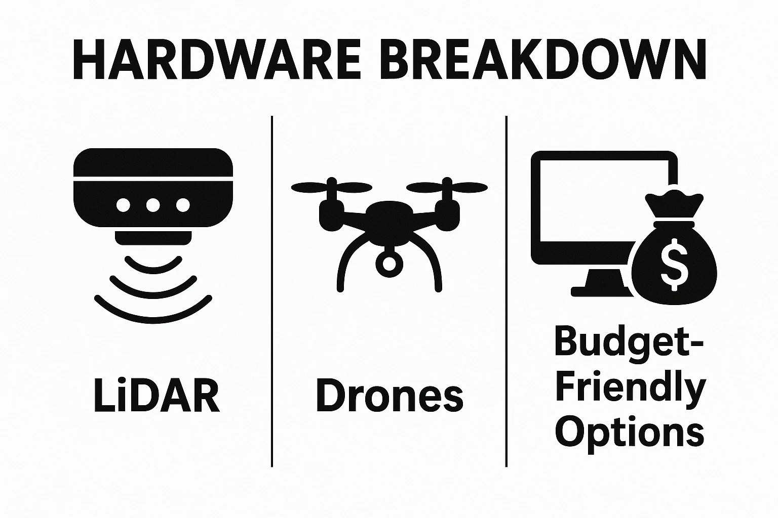
Hardware Breakdown: Tools and Their Price Tags
The hardware you pick is the backbone of reality capture, and it’s where most of your upfront cash flows. In 2026, the market’s packed with options, from budget-friendly to “sell your car” territory. I’ve tinkered with enough of these to know you don’t always need the priciest kit – here’s the lowdown.
LiDAR Scanners: Precision at a Premium
LiDAR (Light Detection and Ranging) uses laser pulses to map spaces with insane accuracy, perfect for architecture or engineering. Terrestrial scanners, mounted on tripods, are the heavy hitters for static setups like buildings or historic sites. Prices range from $12,000 for entry-level models to $170,000 for top-tier units with long-range capabilities. Most pros land around $35,000-$80,000 for a solid mid-range option.
Handheld LiDAR scanners are lighter and more mobile, great for smaller spaces or quick scans. These start at $1,000 for basic models (think smartphone add-ons) and climb to $30,000 for advanced SLAM-based units that track motion in real time. They’re less precise but versatile for industrial design or tight spots.
Mobile LiDAR, strapped to vehicles or backpacks, tackles big areas fast, like roads or campuses. Expect $50,000-$200,000, depending on speed and range. These shine for urban planning but need skilled operators.
Drones: Aerial Powerhouses
Drones are a go-to for capturing wide areas, either through photogrammetry (stitching photos) or LiDAR. Quadcopters, the nimble ones, cost $2,000-$20,000 – $2,000 gets you a decent mapping drone, while $20,000 buys rugged models with better cameras for construction or real estate. Fixed-wing drones, built for long flights over vast terrains, run $10,000-$50,000, ideal for agriculture or surveys.
LiDAR-equipped drones are the big spenders, starting at $20,000 and soaring to $250,000 for systems that penetrate vegetation for forestry or archaeology. They’re pricey but unbeatable for detailed terrain models. I once saw a team save weeks on a highway scan with one of these – worth it if the project’s big.
Budget-Friendly Options: Cameras and Sensors
For lighter needs, 360-degree cameras capture panoramic views for virtual tours or basic documentation. Prices span $350-$5,000 – $350 gets you an entry-level model for real estate, while $5,000 buys pro-grade for crisp VR walkthroughs. Structured light scanners, which project patterns for surface mapping, cost $2,000-$20,000, great for small objects in manufacturing or medical fields.
Depth-sensing cameras, often in smartphones or AR gear, are the cheapest at $300-$3,000. They’re handy for quick scans or gaming but lack the precision for industrial use. I’ve used these for small home reno projects – they’re not perfect, but they get the job done cheap.
Hardware Price Snapshot
- Terrestrial LiDAR: $12,000-$170,000 (mid-range $35,000-$80,000).
- Handheld LiDAR: $1,000-$30,000 (entry-level under $5,000).
- Quadcopters: $2,000-$20,000 (basic mapping at low end).
- Fixed-Wing Drones: $10,000-$50,000 (large-area surveys).
- LiDAR Drones: $20,000-$250,000 (high-precision terrain).
- 360-Degree Cameras: $350-$5,000 (VR or real estate).
- Structured Light/Depth Sensors: $300-$20,000 (basic to small-object precision).
Pro tip: Renting cuts costs 50-70% for one-offs – saved me a bundle on a short-term gig.
Software Costs: From Free to Pro-Grade
Once you’ve got your data, software turns it into usable models, and this is where costs can creep up if you’re not careful. In 2026, you’ve got options from free to five-figure buys, each with trade-offs.
Free and Open-Source Tools
For beginners or tight budgets, free tools are a godsend. Meshroom handles photogrammetry, turning photos into 3D models for $0. CloudCompare is great for point cloud analysis, also free. Blender with add-ons can model and visualize without cost. These lack advanced features but are perfect for learning or small jobs. I started with these on a hobby project and was shocked at how capable they are.
Subscription-Based Software
Pro work often demands paid software with robust support. Autodesk ReCap Pro, ideal for LiDAR and BIM, costs $50 monthly or $405 yearly. It’s a favorite for construction due to CAD integration. Pix4D, tailored for drone photogrammetry, starts at $241 monthly or $2,900 annually for advanced tiers like mapper or survey, perfect for geospatial tasks.
RealityCapture, now under Epic, is free for companies earning under $1 million annually, students, or hobbyists – huge win for small teams. Bigger firms pay $1,250 yearly per seat. It’s fast and handles massive datasets, a go-to for gaming or architecture.
Perpetual Licenses
If subscriptions aren’t your vibe, one-time buys save long-term. Agisoft Metashape Pro is $3,499, great for surveying or archaeology with no recurring fees. Leica Cyclone subscriptions start at $4,500-$5,115 yearly for REGISTER 360 PLUS, but legacy perpetual licenses hit $7,000-$20,000. Trimble RealWorks tiers from $1,000-$5,000 annually, with older one-time buys around $10,000+. These are heavy-duty for civil engineering but need beefy hardware.
Pick based on use frequency – subscriptions for flexibility, perpetuals for long-term savings.
Hidden Costs: The Stuff You Didn’t See Coming
Beyond gear and software, reality capture sneaks in extras that can inflate your budget if ignored. I learned this the hard way when a “cheap” scan job doubled due to post-processing fees.
Data Processing and Cleanup
Raw scans are messy – full of noise or misaligned points. Cleaning them up, often with tools like CloudCompare or ReCap, can be done in-house if you’ve got skills. Outsourcing to freelancers or firms? Expect $500-$5,000 per project, depending on complexity. Aligning multiple scans for a cohesive model adds similar costs.
Model Creation and Integration
Turning scans into usable 3D models for CAD or BIM takes time. Manual modeling in Revit or AutoCAD can add 10-20% to your budget, especially for detailed engineering work. Texturing for VR or animations, using tools like Unity, might cost $1,000-$10,000 if you hire pros for polished visuals.
Storage and Cloud Fees
Large datasets – think terabytes for high-res point clouds – demand serious storage. Local drives are a one-time $200-$2,000, but cloud services like AWS or Google Cloud run $100-$1,000 monthly based on data size and access frequency. Retrieval fees can sting if you’re not archiving smartly.
Training and Labor
New to reality capture? Training or certifications cost $500-$2,000 per person, covering operation or analysis. Operator time, especially for complex setups, adds labor costs – think $50-$150/hour for skilled techs. Skimp here, and you risk bad scans that waste more.
Typical Hidden Costs
- Data Cleanup: $500-$5,000/project (freelance or in-house).
- Model/BIM Work: 10-20% of project cost (manual tweaks add up).
- Cloud Storage: $100-$1,000/month (scales with data volume).
- Training/Labor: $500-$2,000 for training, $50-$150/hour for operators.
Budget an extra 20-30% for these to avoid my rookie mistakes.
Project Scale: How Size and Detail Impact Costs
The scope of your project is a huge cost driver – small, medium, or large, each has its own price tag and gear needs.
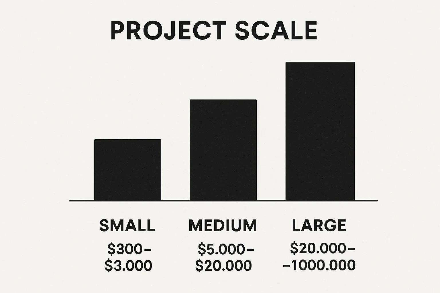
Small-Scale Projects
Scanning single objects, rooms, or small interiors for real estate or design? Handheld scanners or 360-degree cameras do the trick in hours. Total cost: $300-$3,000, including basic processing. These are quick, low-data jobs – perfect for dipping your toes.
Medium-Scale Projects
Buildings, factories, or infrastructure sites need more firepower, like terrestrial LiDAR or drones. Capture takes days, with processing pushing costs to $5,000-$20,000. Data complexity grows, and you might need multiple scans for full coverage.
Large-Scale Projects
Mapping landscapes, cities, or massive construction zones? Aerial LiDAR or fixed-wing drones are your friends, but they take weeks and cost $20,000-$1000,000+. High-res needs and extensive post-processing drive the price, especially for geospatial or mining work.
Accuracy’s Price
Low-res scans for visuals keep costs down – think VR or real estate. High-res for engineering or preservation? Expect 50% higher costs due to longer scans and beefier processing. I’ve seen teams save by mixing resolutions – high only where it counts.
Cost by Scale
- Small (Rooms/Objects): $300-$3,000 (quick, handheld gear).
- Medium (Buildings/Sites): $5,000-$20,000 (mixed tools, multi-day).
- Large (Landscapes/Cities): $20,000-$1000,000+ (aerial, heavy processing).
Plan phased scans for big jobs to spread costs.
Saving Without Sacrificing: Cost-Cutting Tips
You don’t have to break the bank to get great results. After a few budget overruns, I’ve honed ways to keep costs lean.
Go Budget-Friendly on Hardware
Photogrammetry with cameras ($350-$2,000) can replace LiDAR for non-critical jobs like real estate or basic models, saving thousands. 360-degree cameras are dirt cheap for VR walkthroughs. Rent high-end gear like LiDAR for one-offs – cuts 50-70% off upfront costs.
Leverage Free Software
Free tools like Meshroom or CloudCompare handle basic photogrammetry or point clouds. They’re not as slick as paid options, but for small jobs, they’re gold. I used these on a low-budget project and got results that impressed clients.
Optimize Processing and Storage
Process locally on a decent workstation to skip cloud fees – can save $100-$1,000 monthly. Use lower resolutions where detail isn’t critical, and compress files to cut storage costs. Archive old data to cheap cold storage to avoid ongoing charges.
Plan Smart, Scan Once
Pre-plan scan locations and use automated drone paths to avoid re-dos. Check data on-site to catch errors early – re-scanning is a budget killer. Calibrate gear properly; a bad setup cost me a day’s work once.
Outsource Strategically
No in-house skills? Freelancers on platforms charge $500-$5,000 for post-processing, cheaper than training a team for occasional jobs. AI tools in modern software automate cleanup, cutting labor hours.
Top Cost-Saving Strategies
- Swap LiDAR for Photogrammetry: Cheaper for visuals, same impact.
- Rent Gear: Ideal for short projects, no maintenance hassle.
- Use Free Tools: Start with open-source for low-cost learning.
- Smart Planning: Avoid re-scans with prep and real-time checks.
- Automate with AI: Speeds up processing, cuts labor costs.
These tricks have shaved thousands off my projects without quality hits.
Wrapping Up: Making Reality Capture Work for Your Wallet
Reality capture in 2026 is a powerful tool, but costs can range from $300 for simple scans to $250,000+ for massive, high-precision jobs. Hardware, software, and extras like storage or labor shape the bill, but with careful choices – renting, free tools, or phased projects – you can keep it manageable. My biggest takeaway? Know your project’s needs, start small, and scale smart. It’s tech that pays off big if you play it right.
Frequently Asked Questions (FAQs)
How much should I budget for a basic reality capture project?
For small jobs like scanning a room or object, expect $300-$3,000, covering affordable gear like 360-degree cameras and free software. Costs rise with more processing or outsourcing.
Is photogrammetry really cheaper than LiDAR?
Yes, photogrammetry using cameras ($350-$2,000) can save 80-90% compared to LiDAR ($1,000-$250,000). It’s great for visuals but less precise, so choose based on accuracy needs.
Should I buy or rent reality capture equipment?
Renting saves 50-70% for one-off or short-term projects, avoiding maintenance costs. Buying makes sense for frequent use, especially if you pick versatile, multi-use gear.
What are the biggest hidden costs to watch for?
Data storage ($100-$1,000/month), post-processing ($500-$5,000/project), and training ($500-$2,000) can add 20-30% to your budget. Plan for these to avoid surprises.

Our Case Studies
We have handled 200+ BIM & VDC projects for commercial, industrial, and residential sectors.
Our work includes:
Formwork design automation
Our client from
California, USA
Suspended ceiling design automation
Our client from
New York, USA
Wall framing design automation
Our client from
California, USA


