Herhangi bir sorunuz var mı? Bize ulaşın!
Ekibimize katılın!
Ücretsiz fiyat teklifi veya danışmanlık talep edin

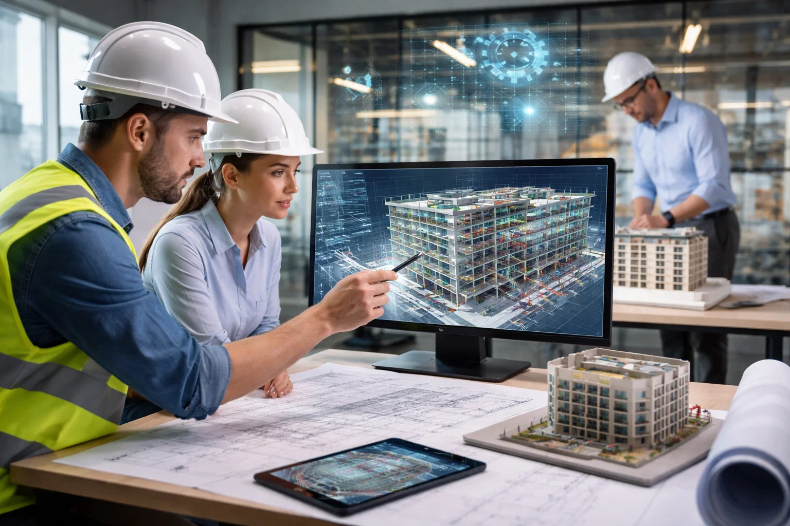
Before any serious design or construction work begins, teams need to understand what’s actually there. Not what’s on old drawings, not what someone remembers from a site visit, but the real, current state of the building or site. That’s where laser scanning and existing conditions modelling come in.
In simple terms, laser scanning captures the physical world in precise 3D, and existing conditions modelling turns that data into a usable digital model. Together, they give architects, engineers, and contractors a reliable foundation to design, coordinate, and build with confidence. Instead of guessing or re-measuring later, teams start with a clear picture of reality.
Powerkh’s Approach to Laser Scanning and Existing Conditions Modelling

Powerkh is a UK-based company with offices in the USA and Ukraine, and a large part of our work revolves around turning real-world data into usable digital models. Laser scanning on its own produces vast amounts of information, but that data only becomes valuable when it is properly structured, interpreted, and integrated into the design process. Through our Scan to BIM and point cloud modeling services, we convert laser-scanned datasets into accurate 3D as-built models that reflect architectural, structural, and MEP systems. Our models support renovation planning at LOD 100–500, coordination, and constructability analysis. We specialize in creating accurate BIM content (Revit families) and detailed structural detailing (steel, rebar, precast, facade) based on point cloud data, giving project teams a reliable foundation instead of assumptions.
We also integrate these models into broader BIM and VDC workflows, helping architects, engineers, contractors, and owners collaborate more effectively from the earliest stages of a project. Our team produces coordinated models, as-built drawings, and documentation at different levels of detail depending on project needs, whether the goal is design development, clash detection, prefabrication planning, or facility operations. By combining laser scanning data with practical engineering knowledge and experience from over 400 projects, Powerkh helps ensure that decisions are based on actual site conditions, not guesswork.
3D Laser Scanning: Technology, Workflow, Data, and Accuracy
Before laser scanning data can be used for design or modelling, it is important to understand what the technology actually captures and how the process works. From the initial measurement of physical space to the creation of usable digital data, each step plays a role in producing reliable information about real-world conditions.
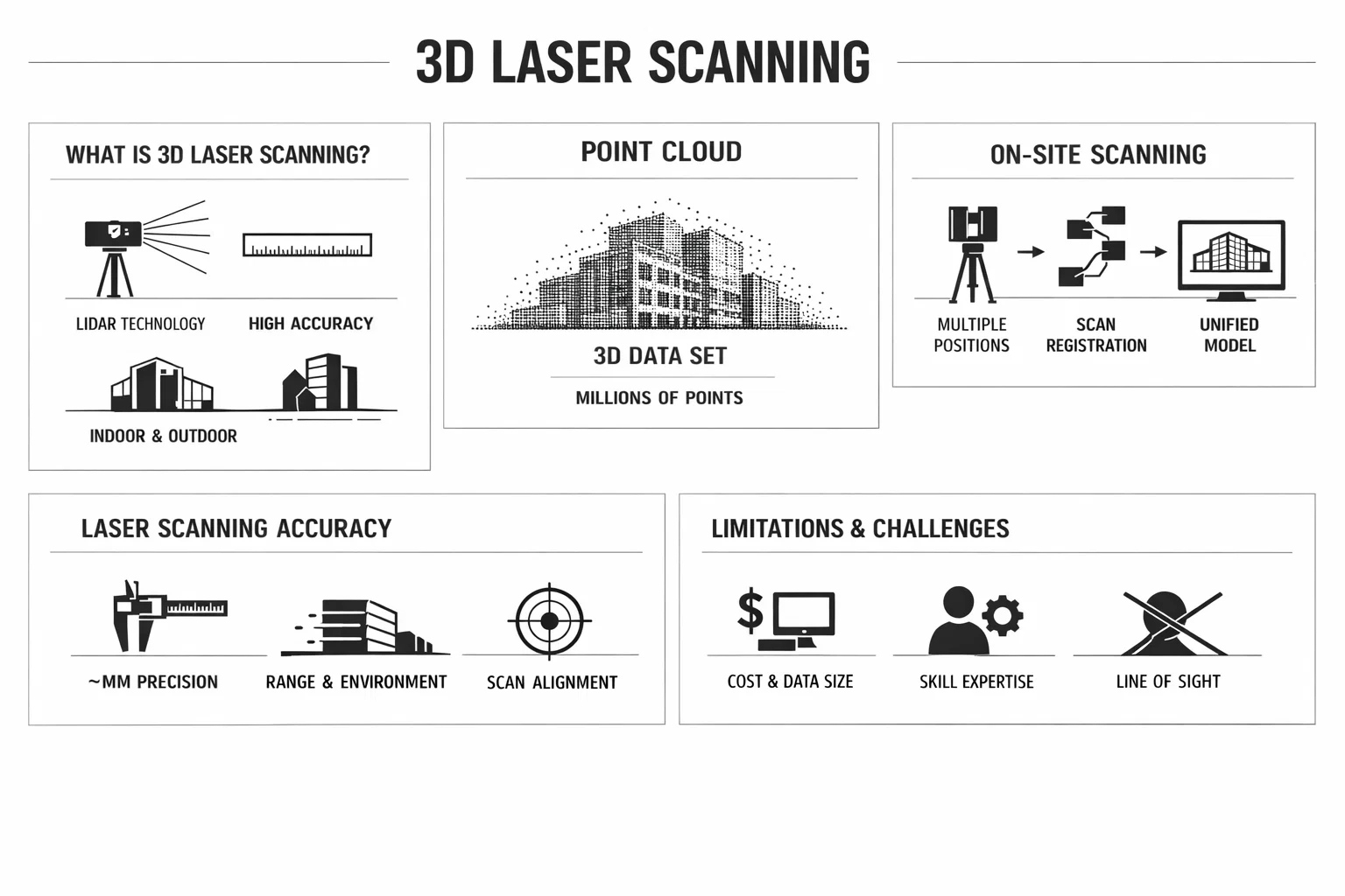
What Is 3D Laser Scanning?
3D laser scanning is a method of capturing precise measurements of physical spaces using light, commonly known as LiDAR – Light Detection and Ranging. The scanner emits laser pulses in all directions, measures the time it takes for each pulse to return after hitting a surface, and calculates the exact distance. Repeated millions of times per second, this process creates a dense digital map of the environment.
Modern Laser Scanning:
- Captures millions of measurements per second
- Achieves millimeter-level accuracy
- Works indoors and outdoors
- Requires minimal physical contact with the site
- Records complete spatial information, not just selected points
Instead of measuring individual dimensions, the technology captures everything within view at once, including structural elements, equipment, and building details.
What Is a Point Cloud?
The result of scanning is a point cloud – a collection of millions or billions of points in three-dimensional space, each with X, Y, and Z coordinates and often color data. Together, these points form a highly detailed digital representation of the scanned environment that can be measured and analyzed.
Because the entire space is recorded, the point cloud can be measured directly, used to extract dimensions, converted into CAD drawings, transformed into BIM models, and shared across project teams. Teams can also retrieve measurements later without returning to the site.
How Scanning Is Performed on Site
A single scan captures only what is visible from one position, so technicians place the scanner at multiple locations to cover the entire area. Each setup records the surroundings from a different viewpoint, and specialized software later aligns all scans into one unified dataset. The process typically involves planning scan positions for full coverage, setting up the scanner on a tripod, capturing scans from multiple viewpoints, recording images for color if needed, registering the scans into a single model, and processing the resulting point cloud. Even large facilities can be documented efficiently, often faster and more thoroughly than with manual measurement.
Accuracy of Laser Scanning
High-end scanners typically achieve accuracy within a few millimeters under field conditions. Precision depends on factors such as equipment quality, distance to surfaces, environmental conditions, surface properties, and the quality of scan alignment. Accuracy is generally highest at shorter distances and gradually decreases as range increases, while still remaining suitable for most construction and engineering applications. Because all measurements originate from a single dataset, results are consistent and less affected by human error or inaccessible areas.
Limitations and Challenges
Despite its advantages, laser scanning is not a magic solution.
- Equipment and Software Costs. High-quality scanners and processing tools represent a significant investment.
- Data Volume. Point clouds are large datasets that require powerful hardware and structured workflows.
- Skill Requirements. Specialized expertise is needed to capture, process, and interpret the data correctly.
- Line-of-Sight Constraints. Scanners cannot capture surfaces blocked by obstacles. Multiple setups are required.
- Level of Detail Decisions. Not every project needs a highly detailed model. Determining the appropriate level of detail is essential to control cost and effort.
Understanding these limitations helps teams use the technology effectively.
Existing Conditions Modelling: From Raw Data to Usable Digital Models
Before design or construction decisions can be made, teams need a clear understanding of what already exists on site. Existing conditions modelling provides that foundation by transforming captured data into structured digital information that reflects the current state of a building or environment.
What Is Existing Conditions Modelling?
Laser scanning captures raw spatial data, while existing conditions modelling converts that data into structured, usable information. It is the process of creating a digital representation of a site, building, or facility as it currently exists, reflecting actual geometry rather than design intent or outdated documentation.
Models may represent:
- Entire buildings
- Specific floors or zones
- Industrial facilities
- Altyapı
- Exterior sites and terrain
- Mechanical or structural systems
Typically developed in BIM software, these models allow teams to analyze, visualize, and coordinate future work against the real environment.
In simple terms: Laser scanning records reality, and existing conditions modelling organizes it for practical use.
Methods Used to Create Existing Conditions Models
Although laser scanning is the most comprehensive source of data, existing conditions models can be created using multiple inputs, often combined to achieve the required level of detail. These sources may include laser scanning point clouds, conventional surveying measurements, photogrammetry from photographs, existing drawings and documentation, and manual site verification. The chosen approach depends on project requirements, budget, accuracy targets, and site accessibility.
Typical Outputs and Deliverables
Deliverables vary depending on project goals and required detail, ranging from raw datasets to fully developed models.
Raw and semi-processed data:
- Registered point clouds
- Colorized scans
- Scan viewing files
- Digital site records
Drawings and models:
- 2D CAD plans
- Sections and elevations
- As-built çizimler
- 3D BIM modelleri
- Mesh models
- Dijital ikizler
- Visualization models
Some projects require only measurement reference, while others demand detailed models suitable for design coordination, construction planning, or facility management.
Why Existing Conditions Modelling Matters
Accurate knowledge of existing conditions is essential for both new construction and renovation projects. Without reliable data, teams are forced to rely on assumptions, which often leads to redesigns, field modifications, delays, and cost overruns.
Design Accuracy and Risk Reduction
Basing decisions on actual geometry rather than approximations significantly improves design reliability. Conflicts between new and existing elements can be identified early, reducing the likelihood of costly changes during construction.
Key advantages include:
- More accurate design solutions
- Early detection of clashes
- Reduced need for on-site adjustments
- Better-informed planning decisions
Improved Collaboration and Coordination
Modern projects involve multiple disciplines working simultaneously, all requiring consistent information. A shared digital model provides a single, reliable reference for architects, engineers, contractors, and owners. It offers a common visual basis for discussion, enables early detection of conflicts, reduces reliance on assumptions, supports remote collaboration, and improves communication between teams. Working from the same dataset makes coordination more predictable and efficient.
Time Savings and Workflow Efficiency
Manual measurement of complex spaces can take days or weeks and may still produce incomplete results. Laser scanning captures comprehensive data much faster, significantly reducing time spent in the field. This leads to fewer site visits, faster data collection, less need for re-measurement, an earlier start to design work, and fewer delays during construction. In many cases, the upfront investment is offset by avoiding problems later in the project.
Long-Term Value Beyond Construction
Existing conditions models remain useful long after construction is complete. They provide a reliable digital record that supports ongoing building operations and future projects, including facility management, future renovations or upgrades, space planning, asset tracking, and documentation of installed systems. Over time, the model becomes a living record of the built environment, supporting informed decisions throughout the building lifecycle.
Applications Across Project Types
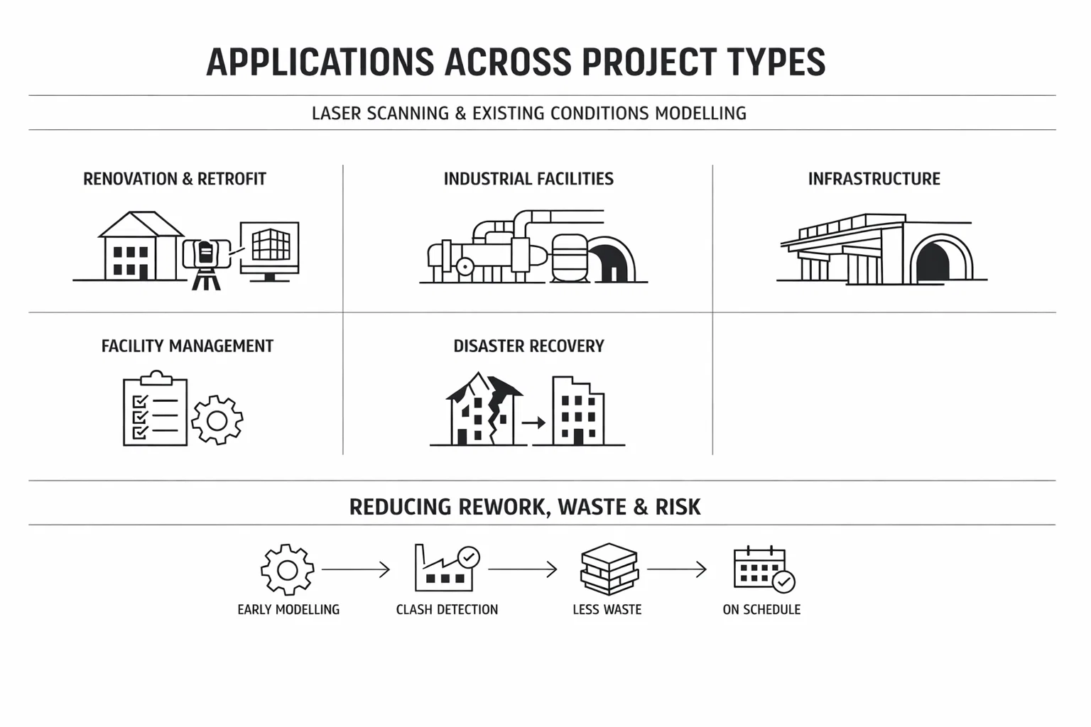
Laser scanning and existing conditions modelling are used across many industries.
- Renovation and Retrofit Projects. Older buildings often lack accurate documentation. Scanning provides reliable data before design begins.
- Industrial Facilities. Complex piping, equipment, and structural systems benefit greatly from precise spatial capture.
- Infrastructure Projects. Bridges, tunnels, and transportation systems require accurate geometric data for upgrades or maintenance.
- Facility Management. Owners can use models for planning maintenance, upgrades, or space utilization.
- Disaster Recovery. Scans can document conditions before and after catastrophic events, supporting insurance and reconstruction efforts.
Laser Scanning vs Traditional Surveying
Traditional surveying remains valuable, especially for large-scale geospatial work, but it typically measures selected points rather than capturing entire environments. Laser scanning complements these methods by providing dense spatial data that records the full geometry of a space. Surveying is known for high accuracy at control points, suitability for large areas, and well-established workflows, while laser scanning offers comprehensive capture, detailed geometry, strong visualization capabilities, and greater efficiency for complex structures. In practice, many projects use both methods together to achieve the best results.
The Role in Modern BIM Workflows
Building Information Modelling relies on accurate input data, since errors in the base model affect everything built on top of it. Existing conditions models provide this foundation by representing the actual state of a site or facility. They support renovation design, coordination of new systems, quantity takeoffs, construction planning, and simulation or analysis. By enabling decisions based on real-world data, these models also contribute to the broader digital transformation of the construction industry.
Sonuç
Laser scanning and existing conditions modelling give project teams something they rarely had in the past – a reliable picture of reality before work begins. Instead of guessing, interpreting old drawings, or measuring the same space multiple times, teams can work from accurate data captured once and reused throughout the project.
Laser scanning records the physical environment in detail, and modelling turns that information into drawings and BIM models that support design, coordination, and construction. The result is fewer surprises, fewer changes in the field, and better decisions from the start. As projects grow more complex, having trustworthy existing conditions data is no longer optional. It is a practical necessity for planning and delivering work with confidence.
SSS
1. What is laser scanning used for in construction?
Laser scanning is used to capture precise measurements of buildings, sites, or infrastructure. It creates a complete 3D record of existing conditions that can support design, renovation, coordination, and documentation.
2. What does existing conditions modelling mean?
It refers to creating a digital model of a building or site as it currently exists. The model is based on real measurements rather than design assumptions or outdated plans.
3. Is laser scanning accurate enough for engineering work?
Yes. Modern scanners typically achieve millimeter-level accuracy under field conditions, which is sufficient for most architectural, engineering, and construction applications.
4. Do you still need surveying if you use laser scanning?
Often yes. Surveying provides control and positioning, while laser scanning captures detailed geometry. Many projects combine both methods.
5. Can the data be used after construction is finished?
Yes. Existing conditions models can serve as long-term documentation for facility management, future upgrades, or space planning.
6. Is laser scanning only useful for renovations?
No. It is valuable for both renovation and new construction projects whenever accurate information about existing conditions is needed.

Bir BIM Projeniz mi Var? Bizimle Konuşun.
Bize UlaşınVaka Çalışmalarımız
Ticari, endüstriyel ve konut sektörleri için 200'den fazla BIM ve VDC projesi gerçekleştirdik.
Çalışmalarımız şunları içermektedir:
Kalıp tasarım otomasyonu
Our client from
California, USA
Asma tavan tasarım otomasyonu
Our client from
New York, USA
Duvar çerçeveleme tasarım otomasyonu
Our client from
California, USA