Herhangi bir sorunuz var mı? Bize ulaşın!
Ekibimize katılın!
Ücretsiz fiyat teklifi veya danışmanlık talep edin

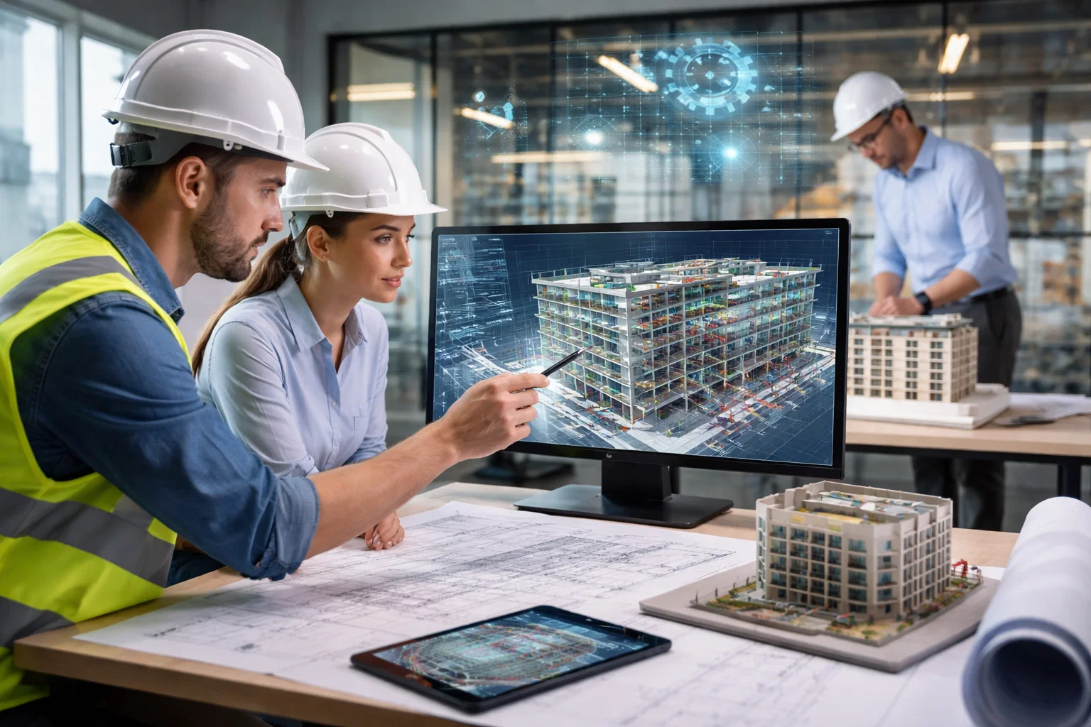
LiDAR scanning is revolutionizing the way building surveys are conducted across the UK. As an advanced technology that captures detailed 3D models of buildings, it helps surveyors provide more accurate data in less time. Companies offering LiDAR scanning services are at the forefront of this shift, helping industries such as architecture, construction, and heritage preservation to make better decisions and streamline their workflows.
With its ability to capture millions of data points quickly and precisely, LiDAR scanning is a game changer for building surveys. This technology allows for the creation of highly accurate 3D models and point clouds that serve as the foundation for further analysis and design. As more UK companies integrate LiDAR into their services, the benefits are clear – faster, more reliable surveys with fewer errors, making it a valuable tool for both large-scale projects and smaller, intricate assessments.
1. Powerkh
| Web sitesi | www.powerkh.com |
| E-posta | [email protected] |
| www.facebook.com/people/Powerkh/100064039650167 | |
| www.linkedin.com/company/powerkh | |
| www.instagram.com/powerkh_com | |
| Adres | 3, Lavinia Walk, Taw Hill, Swindon SN25 1AP |
| Telefon | +44 7490 426678 |
At Powerkh, we integrate LiDAR scanning into our digital construction consultancy services to enhance the accuracy and efficiency of building surveys across the UK. Using terrestrial laser scanning, we capture and model existing buildings, creating detailed 3D point clouds that provide a verified base for design and coordination. This technology allows us to process and validate real-world conditions, ensuring that design decisions are based on reliable, up-to-date data. By aligning this information with project coordinates, we eliminate discrepancies and ensure that design intent is maintained from concept through to construction.
LiDAR scanning serves as a critical tool in our comprehensive approach to design continuity. Through point cloud processing and Revit modeling of existing conditions, we provide a solid foundation for our clients to proceed with confidence. With Powerkh’s use of LiDAR scanning, building survey companies can access a high level of precision and reliability, ensuring smoother coordination, faster decision-making, and fewer errors during the construction process. By seamlessly integrating this technology into our existing services, we help bring designs to life with verified, actionable insights.
Önemli Noktalar:
- Engineering-led consultancy with a focus on design continuity
- Comprehensive services from design to construction, with emphasis on BIM and reality-based verification
- Expertise in structural and MEP design support, laser scanning, and progress verification
- Commitment to risk reduction through detailed coordination and deviation monitoring
Hizmetlerimiz:
- Laser Scanning and Existing Conditions Modelling
- Structural and MEP Design Support
- Design Coordination and Critical Zone Resolution
- Technical Design and Constructability Review
- Design Continuity Support
- Deviation Monitoring and Engineering Review
- As-Built Verification and Handover Support
2. LiDAR.CO.UK

| Web sitesi | www.lidar.co.uk |
| E-posta | [email protected] |
| www.facebook.com/MerrettSurvey | |
| Adres | 3, Merlin Business Park, Fairoak Close, Exeter Airport, EX5 2UL, UK |
| Telefon | +44 (0) 1392 362161 |
LiDAR.CO.UK is a provider of advanced LiDAR scanning services, specializing in both aerial and terrestrial laser scanning for various industries. Their team is skilled at delivering precise and detailed survey data, ensuring the highest quality LiDAR outputs for clients in diverse sectors, including land development, telecommunications, and environmental monitoring. By combining aerial and ground-based scan data, they can provide comprehensive coverage for any project, regardless of the terrain or complexity. Their services also include independent quality control, ensuring the accuracy of LiDAR data purchased from other providers, and processing LiDAR data to create digital elevation models, topographic maps, and more.
Whether it’s surveying vast urban landscapes or difficult-to-reach areas like coastal zones, their technology excels in capturing high-resolution 3D data. With a focus on delivering clear and actionable insights, LiDAR.CO.UK plays a crucial role in helping clients make informed decisions based on precise survey data.
Önemli Noktalar:
- Provides independent quality control to ensure accuracy of LiDAR data
- Experienced in surveying across various environments worldwide
- Delivers high-resolution 3D models, topographic maps, and digital elevation models
- Works in sectors such as telecommunications, land development, and environmental monitoring
Hizmetlerimiz:
- Aerial LiDAR Services
- Terrestrial Laser Scanning
- LiDAR Data Processing
- Digital Elevation Models (DEMs)
- Contour Models
- Topographic Feature Extraction
3. WHITFIELD:DESIGN Architects

| Web sitesi | whitfield-design.co.uk |
| E-posta | [email protected] |
| www.facebook.com/WhitfieldDesign | |
| www.instagram.com/whitfielddesign | |
| Adres | 1650 Arlington Business Park, Theale, Reading, RG7 4SA |
| Telefon | 07810794436 |
WHITFIELD:DESIGN Architects offers modern solutions for construction and land projects. They use 3D LiDAR scanning and virtual reality so clients can see and improve their designs. By scanning properties and making detailed 3D models, WHITFIELD:DESIGN gives reliable info that guides design ideas, studies, and layout planning. The LiDAR scanning service is key to ensuring exact floor plans and CAD drawings, which are important early on for decisions and project growth.
The firm uses new LiDAR tech to create virtual tours, point clouds, and 3D models, which helps clients grasp spaces and decide on designs before building begins. This cuts down on problems during building and keeps projects on track. WHITFIELD:DESIGN works with homeowners, property developers, and construction pros, providing a team effort that delivers well-made spaces.
Önemli Noktalar:
- Specializes in 3D LiDAR scanning and virtual reality services
- Creates detailed floor plans, CAD drawings, and 3D models from scan data
- Provides accurate point cloud data for architectural planning and development
- Focused on delivering precise results to support early-stage decision-making
Hizmetlerimiz:
- 3D LiDAR Scanning
- Virtual Reality Design Tours
- Floor Plan Creation
- CAD Plan Generation
- Nokta Bulutu Veri İşleme
- 3D Model Oluşturma
4. Castle Surveys
| Web sitesi | castlesurveys.co.uk |
| E-posta | [email protected] |
| www.linkedin.com/company/castle-surveys-ltd | |
| www.instagram.com/castlesurveys | |
| Adres | 54 Poland St, Soho, London, W1F 7NJ |
| Telefon | 020 3728 2884 |
Castle Surveys is a surveying company that’s all about making the most of LiDAR scanning to gather accurate measurements and data. They use both ground-based (terrestrial) and aerial LiDAR systems, so they’re able to capture high-def data from all kinds of angles and environments. Whether it’s for land development, construction, environmental monitoring, or even archaeology, their technology helps clients get a clear, detailed picture through 3D models and topographic maps. This means clients can make decisions backed by reliable, precise data from the start.
One of the things Castle Surveys is really proud of is how efficiently they can collect this data. Their LiDAR scanning methods are much quicker than traditional surveying, which means they can cover more ground in less time. They use a mix of static and mobile units, plus UAVs with LiDAR sensors, to make sure they get the best quality data for each project. This combination of tools and tech has earned them a solid reputation as a go-to choice for clients across the UK who need detailed and dependable LiDAR surveys for everything from construction to environmental monitoring.
Önemli Noktalar:
- Provides high-definition 3D models and topographic maps
- Works across industries such as construction, land development, and environmental monitoring
- Utilizes UAVs equipped with LiDAR sensors for efficient data collection
- Known for delivering precise data in a fraction of the time required by traditional surveying methods
Hizmetlerimiz:
- LiDAR Surveying (Terrestrial and Aerial)
- 3D Modeling and Point Cloud Data Processing
- Topographic Mapping
- Terrain and Elevation Analysis
- Environmental Monitoring and Surveying
- Archaeological Site Surveying
5. Double Check Digital Engineering

| Web sitesi | doublecheckltd.co.uk |
| E-posta | [email protected] |
| www.linkedin.com/company/double-check-digital-engineering | |
| Adres | Office 1, Unit 4 16 Brown Street North Leigh WN7 1BU |
| Telefon | 01942 665 760 |
Double Check Digital Engineering specializes in 3D LiDAR scanning and point cloud surveys, using advanced laser technology to create ultra-accurate “digital twins” of sites. Their service captures millions of data points with precision, making sure that the real-world conditions of a building or site are accurately reflected in the model. This approach helps to detect clashes and errors before any construction begins, ultimately preventing costly mistakes and delays. By replacing manual surveys with LiDAR scanning, Double Check ensures that design decisions are based on real data, giving clients the certainty they need to move forward with their projects.
Their use of LiDAR scanning technology also eliminates the need for repeated site visits, saving time and reducing costs. The collected data is processed into a comprehensive point cloud, which can be used for further design and planning. Whether it’s for steel structures, retrofits, or large-scale projects, their scanning solutions provide a foundation of certainty and accuracy. With decades of hands-on experience in construction and digital surveying, Double Check offers a streamlined and reliable process for every project.
Önemli Noktalar:
- Utilizes advanced LiDAR scanning to create precise “digital twins” of sites
- Helps clients detect clashes and errors early in the design process
- Reduces the need for multiple site visits, saving time and costs
- Provides comprehensive point cloud data for further design and planning
- Experience in both large-scale and smaller, complex projects
Hizmetlerimiz:
- 3D LiDAR Scanning and Point Cloud Surveys
- Clash Detection and Pre-Fabrication Design Support
- Dijital İkiz Oluşturma
- Site Measurement and Surveying for Steel Structures
- Modeling and Drawing Production from Point Cloud Data
6. Scanix

| Web sitesi | www.scanix.co.uk |
| E-posta | [email protected] |
| www.facebook.com/ScanixNik | |
| www.linkedin.com/in/nik-abel-029870187 | |
| Telefon | 07547 727 495 |
Scanix provides LiDAR scanning to make precise 3D models fast. Their 3D laser scans grab up to a million data points each time, so you get great accuracy whether your project is big or small. It’s perfect when you need surveys with many details, like when you’re dealing with existing buildings and it’s hard to measure things the usual way. The LiDAR data fits right into CAD and BIM, for easier and quicker design.
Scanix stands out because they give you good LiDAR surveys that don’t cost too much, and they fit right into how you design. They make correct 2D floor plans and 3D models, so builders, engineers, and architects can decide with good information early. You can also visit sites virtually and measure from far away, which saves time since design teams don’t have to be there in person to get what they need.
Önemli Noktalar:
- Offers high-precision 3D laser scanning with up to one million data points per scan
- Focuses on speed and accuracy to save time and reduce costs
- Data integrates easily into CAD and BIM systems for seamless project planning
- Provides virtual site visits for remote measurements and inspections
Hizmetlerimiz:
- 3D LiDAR Scanning
- 2D Floor Plan Generation
- BIM Services and Integration
- Virtual Site Visits and Measurements
- 3D Modeling and Point Cloud Data Processing
7. Global Technical Services

| Web sitesi | globaltechnicalservices.co.uk |
| E-posta | [email protected] |
| www.facebook.com/GlobalTechGTS | |
| x.com/GTSGlobalTech | |
| www.linkedin.com/company/gtsglobaltech | |
| Adres | Harris House, Moorbridge Road, Bingham, Nottingham NG13 8GG |
| Telefon | 0115 989 9800 |
Global Technical Services (GTS) is a company that’s known for its expertise in fire safety, but they also offer LiDAR 3D scanning services to create highly accurate digital models. While fire safety is a core focus, GTS uses LiDAR scanning to help their clients build detailed digital twins of their spaces. This scanning technology is perfect for building surveys, as it allows for precise, immersive models that can be used for a range of applications like building information modeling (BIM), fire safety assessments, and even structural analysis. The ability to capture and process detailed point clouds ensures that their projects meet regulatory requirements and are executed with the highest precision.
What makes GTS stand out is their ability to blend fire safety with cutting-edge digital surveying technology. They offer a wide range of services, from pre-construction surveys and site inspections to fire risk assessments and 3D virtual tours. It’s this combination of fire safety expertise and advanced surveying that allows GTS to provide a full-spectrum solution for construction, design, and safety.
Önemli Noktalar:
- Strong focus on fire safety with expertise in fire risk assessments and compliance
- Offers LiDAR 3D scanning to create accurate digital twins and detailed point clouds
- Seamless integration of LiDAR data into BIM and project workflows for better design planning
Hizmetlerimiz:
- LiDAR 3D Scanning for Building Surveys
- BIM and Point Cloud Data Integration
- Fire Safety Assessments and Surveys
- Pre-Construction and Post-Construction Site Surveys
8. Clarion

| Web sitesi | www.clarion-surveyors.co.uk |
| E-posta | [email protected] |
| www.facebook.com/people/Clarion-Chartered-Surveyors/100080409604489 | |
| www.instagram.com/clarioncharteredsurveyors | |
| Adres | The Farm House, Ivyhouse Lane, Hastings, TN35 4NN |
| Telefon | 01424 437 978 |
Clarion is a surveying and architectural design firm based in the UK that offers a range of services, including LiDAR scanning. They use an in-house Leica LiDAR unit to provide accurate, automated laser measuring and recording of buildings. This technology captures up to 360,000 dimensions per second, which is then processed into a point cloud, an incredibly precise digital representation of the scanned area. With LiDAR scanning, Clarion provides detailed 3D models and floor plans of indoor spaces, ensuring that their surveys are reliable and up-to-date. Their scans cover everything from structural features like walls and windows to external building dimensions, making it easier for their clients to visualize and plan projects.
The firm uses LiDAR scanning not only to ensure precision but also to simplify the surveying process. By eliminating the need for manual measurements, Clarion saves time and reduces the likelihood of human error, which can often lead to costly rework. The point cloud data is then transferred into AutoCAD to generate comprehensive plans and elevations, streamlining the design process for architects, builders, and surveyors. Whether for large construction projects or smaller renovations, Clarion’s use of LiDAR technology improves workflow and ensures that the final output reflects the true as-built conditions of a site.
Önemli Noktalar:
- In-house Leica LiDAR unit for automated, precise measurements
- Captures 360,000 dimensions per second for high accuracy
- Creates detailed 3D models and floor plans from LiDAR scan data
- Uses point cloud data for accurate planning and design integration
- Transforms complex survey data into easily accessible AutoCAD plans and elevations
Hizmetlerimiz:
- LiDAR Scanning for Building Surveys
- 3D Model Creation from LiDAR Data
- Floor Plan Generation
- External Building Dimension Scanning
- AutoCAD Data Integration
- Nokta Bulutu Veri İşleme
9. TheCADdesigner
| Web sitesi | www.thecaddesigner.co.uk |
| E-posta | [email protected] |
| www.linkedin.com/company/thecaddesigner-ltd | |
| Adres | 26 Kirby Road, Gretton, Northamptonshire NN17 3DB |
| Telefon | 07871 305516 |
TheCADdesigner includes 3D LiDAR scanning in their design and modeling. This lets them quickly make steelwork packages and as-built plans. Using LiDAR, they get precise, high-density point cloud data on location. Then, they use this data to build detailed 3D models with Tekla software. This lets them design and model steel structures using real-world data, which makes sure everything fits properly before manufacturing starts. This tech not only makes things more precise, but it also shortens the time spent on regular survey dimensions and gets rid of pricey mistakes from manual measurements.
TheCADdesigner stands out because they can change LiDAR scan data into an interactive digital copy. Clients can walk through their site in 3D from anywhere. They can use the digital model to take measurements or check conditions from afar. This ability, along with making detailed CAD and BIM models from LiDAR data, betters teamwork and simplifies the design process. Whether it’s for steel detailing, warehouse surveys, or complicated building projects, TheCADdesigner gives a fresh way to survey and design that lowers the need for on-site trips and fixes.
Önemli Noktalar:
- Integrates scan data directly into Tekla software for steel design and modeling
- Offers an interactive 3D digital twin for virtual site walks and remote measurements
- Reduces the time needed for traditional surveying and model adjustments
Hizmetlerimiz:
- Scan-to-Design Modeling in Tekla Software
- Scan-to-CAD for As-Built Plans and Elevations
- 3D Virtual Tours and Digital Twin Creation
- Point Cloud Data Processing for 3D Modeling
10. ScanTech Digital

| Web sitesi | www.scantechdigital.com |
| E-posta | [email protected] |
| x.com/ScanTechDigital | |
| www.linkedin.com/company/scantech-digital | |
| www.instagram.com/scantechdigital | |
| Adres | 321 Bradford Street, Digbeth, Birmingham, B5 6ET |
| Telefon | 0333 577 5752 |
ScanTech Digital uses 3D laser scanning for different construction and surveying jobs. They’re good at getting exact measurements of buildings and spaces with LiDAR, making detailed 3D models for design and construction. They scan from different spots to create a point cloud, giving a clear and correct picture of the site. ScanTech makes sure measurements are exact, which lowers the chance of mistakes and fixes later on, whether it’s for big businesses, homes, or old historical places.
They aim to make surveying easier. LiDAR scanning helps them get data fast and right, so they don’t have to measure by hand or visit the site many times. ScanTech focuses on being fast and correct, giving clients 3D models, CAD drawings, and BIM data that fit well into their work. This saves time and money and makes sure design choices are based on the best data.
Önemli Noktalar:
- Delivers high-precision point clouds and 3D models for construction and design
- Reduces the need for repeated site visits, saving time and costs
- Focuses on accuracy and reliability, especially for complex sites
- Provides BIM-ready data that integrates into existing project workflows
Hizmetlerimiz:
- 3D LiDAR Scanning for Building Surveys
- Scan to BIM and CAD Data Processing
- Model Validation and Clash Detection
- 360° Progress Monitoring and Virtual Tours
- Aerial Surveys and Topographical Surveys
11. Digital Surveys
| Web sitesi | www.digitalsurveys.co.uk |
| E-posta | [email protected] |
| Adres | Unit A, Picton Manor Ellison Place Tyne and Wear NE1 8XG |
| Telefon | 07791297798 |
Digital Surveys provides survey and measurement services, such as 3D LiDAR scanning. Their team has always adopted new tech early, making them early adopters of LiDAR and 3D laser scanning systems. From city models to small parts, their scanning methods create point clouds that correctly show the sites surveyed. Digital Surveys works with industries like oil and gas, architecture, and renewable energy, delivering 3D models that act as the base for projects in many areas.
Their LiDAR scanning service does more than just collect data fast. By using scanners, they can gather millions of data points faster than traditional methods, while keeping accuracy under a millimetre. They can work in tough places, like offshore sites or factories, ensuring that clients get data without the risks or delays of manual surveys.
Önemli Noktalar:
- Specializes in LiDAR scanning and 3D laser scanning for various industries
- Provides high-precision point clouds with sub-millimetre accurac
- Works across multiple sectors including oil and gas, petrochemical, and renewable energy
- Expert at adapting to challenging environments and conditions
Hizmetlerimiz:
- 3D LiDAR Scanning and Point Cloud Data Capture
- Scan to BIM and CAD Services
- 3D Modelling and Inspection
- Asset Management and Facility Surveys
- Digital Elevation Models
- Point Cloud Processing and Data Integration
12. Vision Survey

| Web sitesi | www.vision.co.uk |
| E-posta | [email protected] |
| www.linkedin.com/company/vision-survey | |
| Adres | Talisman House, Jubilee Walk Crawley RH10 1LQ |
| Telefon | 01293 223 435 |
Vision Survey Ltd is a surveying company offering high-precision laser scanning services across the UK. They use advanced terrestrial laser scanners to capture millions of data points, producing accurate point clouds and 3D models that support design, planning, and construction. Their LiDAR scanning service is ideal for a range of applications, including measured building surveys, as-built verification, and clash detection. By quickly capturing detailed site data, Vision Survey helps clients make informed decisions without the usual delays or errors associated with traditional survey methods.
Vision Survey’s laser scanning services are particularly useful for environments where safety and minimal disruption are crucial, such as live construction zones or heritage buildings. Their technology allows them to survey complex geometries and difficult-to-reach areas with ease, ensuring high-quality results. Whether for construction planning, heritage recording, or BIM modelling, Vision Survey delivers precise data that can be easily integrated into various design and construction workflows, offering clients a clearer understanding of their sites.
Önemli Noktalar:
- Offers high-precision LiDAR scanning with millimetre-level accuracy
- Ideal for complex environments like heritage sites and live construction zones
- Fast data capture with minimal disruption to ongoing work
Hizmetlerimiz:
- 3D LiDAR Scanning for Measured Building Surveys
- BIM Modelling and Digital Twin Creation
- As-Built Verification and Clash Detection
- Heritage and Façade Recording
- Topographical and Site Surveys
13. Glanville Geospatial

| Web sitesi | www.glanvillegeospatial.co.uk |
| E-posta | [email protected] |
| www.linkedin.com/showcase/glanville-geospatial | |
| Adres | Unit 2 Central Court, Central Avenue, Lee Mill Industrial Estate , Ivybridge, Devon PL21 9PE |
| Telefon | 01752 690400 |
Glanville Geospatial uses LiDAR scanning to provide detailed 3D digital preservation and analysis for a range of projects. Their laser scanning technology allows them to capture data from complex or hazardous environments, such as cliffs, retaining walls, or industrial plants, where traditional surveying methods may be difficult or unsafe. Whether it’s for topographical surveys, structural analysis, or volumetric measurements, Glanville ensures they provide accurate and reliable data that supports various design and construction processes. Their service is especially beneficial for environments that require minimal disruption or involve sensitive sites.
Glanville’s LiDAR scanning service is highly versatile, with the ability to adapt to a variety of project needs. From capturing detailed surface data for urban planning to providing volumetric analysis for quarry stockpiles, their approach ensures precise data collection. Their in-house CAD team processes the point cloud data into 3D models and BIM objects, which can be easily integrated into design systems like Autodesk Revit or SolidWorks. This helps clients move forward with projects based on verified data, reducing the need for rework and enhancing decision-making throughout the lifecycle of the project.
Önemli Noktalar:
- Provides accurate and reliable data for topographical surveys and structural analysis
- Offers versatile solutions for a range of industries, including construction, industrial plants, and heritage
- Works with in-house CAD team to process point cloud data into 3D models and BIM objects
Hizmetlerimiz:
- 3D Modelling and BIM Integration
- Structural and Volumetric Analysis
- Heritage and Urban Planning Surveys
- Point Cloud Data Processing and CAD Drawing Generation
- Laser Scanning for Hazardous and Difficult-to-Reach Environments
Sonuç
In conclusion, the rise of LiDAR scanning technology has revolutionized how building survey companies in the UK approach data collection. Whether it’s through capturing high-precision point clouds for construction projects, providing digital models for architectural planning, or surveying complex and hazardous environments, LiDAR scanning has proven to be a game-changer. Companies like ScanTech Digital, Vision Survey, and Glanville Geospatial have demonstrated the versatility and effectiveness of this technology, each bringing their own strengths to the table.
What stands out across these firms is their ability to adapt the power of LiDAR scanning to meet the unique demands of various industries, from heritage preservation to large-scale infrastructure development. The precision and efficiency of LiDAR not only help save time and costs but also improve safety and accuracy – critical factors in today’s fast-paced construction environment. With continued advancements in the technology, it’s clear that LiDAR will remain a cornerstone in the future of building surveys, offering even more opportunities to enhance project outcomes and streamline workflows. Whether you’re looking to map out a new build or assess an existing structure, LiDAR scanning is a tool that ensures you have the most reliable data at your fingertips.

Bir BIM Projeniz mi Var? Bizimle Konuşun.
Bize UlaşınVaka Çalışmalarımız
Ticari, endüstriyel ve konut sektörleri için 200'den fazla BIM ve VDC projesi gerçekleştirdik.
Çalışmalarımız şunları içermektedir:
Kalıp tasarım otomasyonu
Our client from
California, USA
Asma tavan tasarım otomasyonu
Our client from
New York, USA
Duvar çerçeveleme tasarım otomasyonu
Our client from
California, USA