هل لديك أي أسئلة؟ اتصل بنا!
انضم إلى فريقنا!
اطلب عرض أسعار أو استشارة مجانية

Quick Summary: A construction site plan is a detailed aerial-view drawing that shows existing and proposed features of a property, including buildings, utilities, grading, drainage, parking, access roads, and landscaping. It serves as a critical blueprint for construction projects, guiding permits, coordinating contractors, and ensuring compliance with local zoning and building codes.
Every construction project—whether it’s a single-family home, commercial building, or large-scale development—starts with one essential document: the construction site plan. This technical drawing captures the full scope of a project from a bird’s-eye view, showing exactly what exists on the property and what’s planned.
But what makes a site plan different from other construction documents? Why do municipalities require it for permits? And what specific elements need to be included?
This guide breaks down everything about construction site plans, from their core components to their role in successful project delivery.
Understanding Construction Site Plans
A construction site plan is a design or sketch of a property that shows the land area and its elements from an aerial view. This perspective reveals a detailed picture of a building project that includes structures, access roads, parking lots, gardens, fences, land boundaries, water channels, entrances and exits, and other critical features.
Think of it as the master blueprint that coordinates all other construction documents. While architectural plans focus on the building itself, the site plan addresses how that building relates to the land, neighboring properties, utilities, and local regulations.
Site plans are more than drawings—they’re technical blueprints that ensure designs are safe, buildable, code-compliant, and ready for permitting. Without an approved site plan, construction projects typically can’t move forward.
Civil Site Plans vs. Architectural Plans
Civil engineers manage a broader range of projects encompassing transportation infrastructure and water systems, while architects focus on buildings. This distinction carries through to their planning documents.
Civil site plans emphasize exterior site conditions—grading, drainage, utilities, paving, and earthwork. Architectural plans detail the building’s interior and exterior design, including floor plans, elevations, and structural details. Both are essential, but they serve different purposes in the construction process.
What's Included in a Construction Site Plan?
The specific requirements for site plans vary by jurisdiction, but certain core elements appear consistently across most projects. Here’s what civil engineers and designers typically include:
Property Boundaries and Legal Description
Every site plan starts with accurate property lines, lot dimensions, and legal descriptions. These boundaries define the buildable area and ensure the project doesn’t encroach on neighboring properties or easements.
Property surveys provide this foundational data. Land surveys can be expensive, often costing up to $3,000 depending on the complexity of the project (they may exceed $10,000 or even more for complex commercial projects or large-scale developments). They can also provide additional details such as zoning information and easements.
Existing Conditions
Site plans document what’s currently on the property before construction begins. This includes existing buildings, trees, utilities, driveways, slopes, water features, and any structures that will remain or be demolished.
Understanding existing conditions helps identify potential challenges—like poor drainage, protected trees, or underground utilities—before they become expensive problems during construction.
Proposed Development
The heart of any site plan shows what’s being built. This includes building footprints with dimensions, new access roads, parking areas with striping and counts, sidewalks, retaining walls, fencing, and landscape features.
Proposed structures are typically shown with their exact location, orientation, and setbacks from property lines—critical information for zoning compliance.
Grading and Drainage
Proper grading ensures water flows away from buildings and doesn’t pool on the site. Site plans include topographic contours showing existing and proposed elevations, drainage patterns, stormwater management features like retention ponds or swales, and connections to municipal drainage systems.
Poor drainage design leads to flooding, foundation problems, and code violations. That’s why grading plans are often the most scrutinized element during permit review.
Utilities
Every building needs connections to infrastructure. Site plans show water service lines, sanitary sewer connections, storm drains, electrical service, gas lines, and telecommunications conduits.
The plan identifies both existing utilities that must be protected and new connections that need to be installed. This coordination prevents costly conflicts during excavation.
Zoning and Code Compliance Information
To demonstrate regulatory compliance, site plans typically include setback dimensions, building height information, lot coverage calculations, parking counts, and required landscaping percentages.
This information allows building officials to quickly verify that the project meets local zoning ordinances without needing to perform their own calculations.
Why Construction Site Plans Are Essential
Site plans aren’t just bureaucratic paperwork. They serve multiple critical functions throughout a project’s lifecycle.
Securing Building Permits
Most municipalities won’t issue building permits without an approved site plan. Building officials use these plans to verify compliance with zoning ordinances, setback requirements, lot coverage limits, parking minimums, and environmental regulations.
The site plan demonstrates that the proposed development meets all applicable codes before construction begins. This protects both the community and the property owner from costly violations.
Coordinating Multiple Contractors
Construction projects involve numerous trades—excavators, utility contractors, concrete crews, framers, landscapers. The site plan serves as the master reference that keeps everyone aligned.
When all contractors work from the same site plan, they know where utilities are buried, where grading needs to slope, and where their work interfaces with other trades. This coordination prevents conflicts and rework.
Managing Site Logistics
Beyond the permanent features, site plans help manage temporary construction needs. They show staging areas for materials, locations for construction trailers, access routes for heavy equipment, and areas that must remain clear for safety.
Systematic site and logistics planning significantly improves project efficiency and safety outcomes.
Preventing Legal Issues
Property boundaries, easements, and setbacks aren’t suggestions—they’re legal requirements. Building too close to a property line or within a utility easement can result in expensive legal disputes, demolition orders, or title issues when selling the property.
An accurate site plan documents compliance and provides legal protection if disputes arise.
Supporting Long-Term Maintenance
After construction ends, site plans become valuable as-built records. They show where underground utilities are located, how drainage systems are configured, and what the approved building footprint includes.
This information is essential for future renovations, additions, or repairs that require excavation near buried infrastructure.
Types of Construction Site Plans
The term “site plan” actually encompasses several related document types, each serving specific purposes.
Preliminary Site Plan
Early in the design process, preliminary site plans explore different layout options and test concepts against zoning requirements. These plans are less detailed but help stakeholders visualize possibilities before committing to final designs.
Construction Site Plan
The construction site plan is the detailed, engineered drawing submitted for permits. It includes all the technical information needed to verify code compliance and guide construction. This is the document most people mean when they say “site plan.”
Landscape Site Plan
Landscape architects create specialized site plans focusing on plantings, irrigation, hardscaping, outdoor amenities, and aesthetic features. These plans coordinate with the civil site plan but emphasize the designed outdoor environment.
Site Utilization Plan
Site utilization plans focus specifically on how space will be used during construction—not the permanent features. They show temporary fencing, material storage, equipment staging, worker facilities, and access routes.
According to industry best practices, site utilization planning improves safety and productivity by organizing the construction zone efficiently.
As-Built Site Plan
After construction, the site plan is updated to reflect what was actually built. As-built plans document field changes, final utility locations, and any deviations from the original design. These become the permanent record for the property.
| Plan Type | الغرض | مستوى التفاصيل | When Used |
|---|---|---|---|
| Preliminary Site Plan | Concept exploration | Low to moderate | Early design phase |
| Construction Site Plan | Permitting and building | High—fully engineered | Permit submission and construction |
| Landscape Site Plan | Outdoor environment design | Moderate to high | Design and installation |
| Site Utilization Plan | Construction logistics | Moderate | During active construction |
| As-Built Site Plan | Permanent record | High—reflects actual conditions | After project completion |
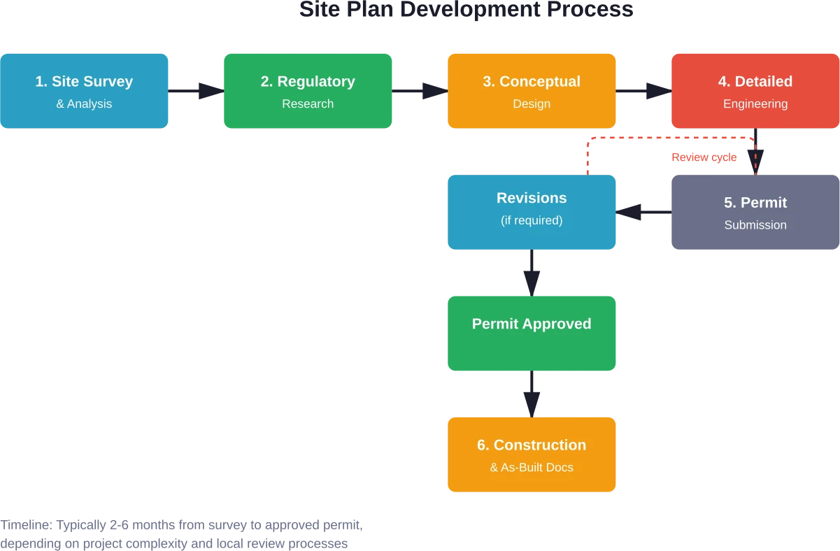
The Site Plan Creation Process
Creating an accurate, code-compliant site plan follows a systematic approach that combines field data, technical design, and regulatory review.
Step 1: Site Survey and Analysis
While a professional land survey is the standard for most projects, some jurisdictions allow ‘plot plans’ based on recorded plat maps or GIS data for minor residential projects (like fences or small sheds) where a full boundary survey may not be mandatory for the initial permit application.
Step 2: Regulatory Research
Before designing anything, engineers research applicable zoning codes, building setbacks, lot coverage limits, parking requirements, stormwater regulations, and environmental restrictions.
Different jurisdictions have different rules. What’s allowed in one municipality might be prohibited in the next.
Step 3: Conceptual Design
With constraints understood, designers develop conceptual layouts that optimize the buildable area while meeting all requirements. This often involves testing multiple options to find the best balance between function, cost, and compliance.
Step 4: Detailed Engineering
Once a concept is approved, civil engineers develop the detailed site plan with precise dimensions, grading calculations, drainage designs, and utility routing. This technical work ensures the design isn’t just compliant but also buildable.
Step 5: Permit Submission and Review
The completed site plan is submitted to local building departments for review. Officials check for code compliance, request revisions if needed, and ultimately approve the plan for construction.
Review timelines vary widely—from a few weeks to several months depending on project complexity and local workload.
Step 6: Construction and As-Built Documentation
During construction, the site plan guides contractors. After completion, it’s updated to reflect any field changes, creating the final as-built record.
Create a Site Plan That Works From Day One

A site plan breaks when real work begins, not on paper. Blocked access, overlapping deliveries, and layouts that don’t match how crews actually move force teams to adjust on the fly. باورخ steps in before that happens, checking how the site will function under real conditions so the plan holds up from day one.
They look at how space is used, how activities overlap, and where the plan will fail once construction starts. Instead of reacting on site, you fix the layout before crews, equipment, and logistics get in the way.
Fix Your Site Plan Early
Work with Powerkh on your site layout to get:
- Access routes that stay clear under real site pressure
- Work zones that don’t need constant replanning mid-project
- Temporary setups that don’t interfere with ongoing works
- Crews moving without delays caused by layout mistakes
- A site that runs according to plan, not constant fixes
If your site plan still relies on assumptions, talk to Powerkh before those assumptions turn into delays on site.
Who Creates Construction Site Plans?
Site plan preparation requires professional expertise. Different specialists contribute depending on project scope and complexity.
Civil Engineers
Civil engineers typically lead site plan development, especially for the technical aspects like grading, drainage, utilities, and paving. They’re licensed professionals who seal and certify the plans for permit submission.
For projects involving significant earthwork or infrastructure, civil engineering expertise is essential.
المهندسون المعماريون
Architects are more deeply involved in the pre-construction phases and often prepare site plans as part of overall project design. They focus on how buildings relate to the site and coordinate with civil engineers on technical details.
Proper site planning is a critical component of comprehensive project delivery in professional architectural practice.
Landscape Architects
When projects emphasize outdoor spaces, landscape architects develop site plans that integrate plantings, hardscaping, and environmental features with the built structures.
Their expertise ensures sustainable designs that respond to natural site conditions.
Land Surveyors
While surveyors don’t typically create the full site plan, they provide the essential base mapping that other professionals build upon. Accurate surveys are the foundation of accurate site plans.
Site Plan Costs and Timeline
Site plan preparation involves professional services that come with associated costs and timelines.
What Affects Site Plan Costs?
Several factors influence how much a site plan costs. Property size matters—larger sites require more survey work and more complex drainage designs. Site complexity plays a role too; steep slopes, wetlands, or numerous existing features increase engineering effort.
Project scope affects pricing. A simple residential addition needs less work than a commercial development with extensive parking and utilities. Jurisdictional requirements vary as well; some municipalities demand more detailed submissions than others.
Generally speaking, residential site plans might range from a few hundred to several thousand dollars, while commercial projects can cost significantly more depending on scope.
Timeline Expectations
Timeline expectations vary drastically by location; in many major metropolitan areas, the permit review process alone can take 6 to 12 months, whereas in smaller jurisdictions it may take only a few weeks. Complex commercial developments can extend to six months or more.
Common Site Plan Mistakes to Avoid
Even experienced professionals encounter pitfalls in site planning. Here’s what to watch for.
Ignoring Setback Requirements
Setbacks aren’t negotiable. Building too close to property lines is one of the most common code violations that results in expensive corrections or demolition orders.
Inadequate Drainage Design
Poor drainage leads to foundation problems, flooding, and liability issues. Site plans must demonstrate positive drainage away from buildings and proper stormwater management.
Overlooking Easements
Utility easements, access easements, and conservation easements limit what can be built in certain areas. Building within easements creates legal problems and potential removal requirements.
Insufficient Parking
Municipalities specify minimum parking counts based on use and square footage. Showing fewer spaces than required means the permit gets rejected.
Missing Utility Coordination
Failing to identify existing utilities or plan proper connections causes construction delays and dangerous situations when excavation begins.
Site Plans and Sustainability
Modern site planning increasingly incorporates sustainable design principles that reduce environmental impact and improve long-term performance.
Low-Impact Development
Low-impact development techniques minimize stormwater runoff through permeable paving, bioswales, rain gardens, and infiltration basins. These features manage water naturally rather than overwhelming municipal systems.
Site Preservation
Preserving existing trees, natural drainage patterns, and habitat areas reduces environmental disruption. Site plans can designate protection zones and minimize grading in sensitive areas.
Efficient Site Utilization
Thoughtful planning maximizes buildable area while minimizing site disturbance. This reduces clearing, grading, and the overall construction footprint.
Energy and Orientation
Site plans affect building energy performance through orientation, shading, and wind exposure. Positioning buildings to optimize solar access and natural ventilation creates long-term efficiency benefits.
Digital Tools for Site Planning
Technology has transformed how professionals create and share site plans.
Computer-Aided Design Software
CAD programs allow precise drafting with accurate dimensions, easy revisions, and professional presentation. Most civil engineering and architectural firms use specialized CAD software designed for site planning.
نمذجة معلومات البناء
BIM extends beyond traditional CAD by creating intelligent 3D models that contain data about every site element. This technology improves coordination and helps visualize complex relationships.
Geographic Information Systems
GIS platforms integrate site plans with geographic data like topography, soil types, flood zones, and zoning overlays. This context helps designers make informed decisions.
Drone Survey Technology
Drones can quickly capture detailed site conditions through aerial photography and photogrammetry, creating accurate base maps faster and less expensively than traditional survey methods for certain applications.
Working with Local Authorities
Successful permitting requires understanding and working with local building departments.
Pre-Submission Consultation
Many jurisdictions offer pre-application meetings where developers can discuss proposed projects before formal submission. These meetings identify potential issues early and clarify expectations.
Understanding Review Processes
Different municipalities have different review procedures. Some conduct internal reviews, while others require public hearings or planning board approvals. Understanding the process prevents surprises.
Responding to Comments
Permit reviewers often request revisions or additional information. Responding promptly and completely keeps the approval process moving forward.
OSHA and Safety Considerations
Construction sites must meet specific safety standards established by occupational safety regulations. While site plans primarily address physical layout, they should consider safe access, adequate staging areas, and compliance with occupational safety requirements.
Different states have OSHA-approved State Plans that are monitored by OSHA and must be at least as effective as OSHA in protecting workers and preventing work-related injuries, illnesses and deaths.
الأسئلة الشائعة
What’s the difference between a site plan and a plot plan?
Plot plans are typically simpler and show basic information like property boundaries and building location. Site plans are more detailed, including grading, drainage, utilities, and compliance with zoning regulations. Some jurisdictions require full site plans for permitting.
Can I create my own site plan, or do I need a professional?
Basic sketches can be created by property owners, but most jurisdictions require site plans to be prepared and certified by licensed professionals such as civil engineers, architects, or surveyors.
How long is a site plan valid for permitting?
Validity depends on local regulations. Some jurisdictions require plans to be updated within 6–12 months, while others require updates only if site conditions change significantly.
What happens if I build without an approved site plan?
Building without approval can lead to fines, stop-work orders, demolition requirements, legal issues, and problems with property sale or insurance. Proper permits and approvals are essential.
Do I need a new site plan for an addition or renovation?
Most additions and major renovations require updated site plans, especially if they change the building footprint or affect drainage. Minor interior changes usually do not require updates.
How detailed do site plans need to be?
Detail levels vary by project type. Typical requirements include property boundaries, building dimensions, setbacks, utilities, parking, and grading. Larger or more complex projects may require detailed studies and calculations.
Can site plans be modified after permit approval?
Minor changes may be allowed without formal updates, but significant changes usually require revised plans and re-approval. It is important to coordinate any modifications with local authorities.
الخاتمة
Construction site plans are far more than regulatory paperwork—they’re essential blueprints that coordinate all aspects of site development from initial design through final construction. These detailed aerial-view drawings show property boundaries, existing conditions, proposed development, grading, drainage, utilities, and compliance information that guides permitting, construction, and long-term property records.
Whether for a single-family home or a large commercial development, professional site planning ensures projects meet code requirements, coordinate contractors, manage site logistics, and prevent costly legal issues. The investment in proper site plan preparation pays dividends throughout the project lifecycle and beyond.
Planning a construction project? Work with qualified civil engineers, architects, or landscape architects to create accurate, compliant site plans that set the foundation for success. The right site plan doesn’t just satisfy permit requirements—it optimizes site potential while protecting your investment for years to come.

دراسات الحالة لدينا
لقد تعاملنا مع أكثر من 200 مشروع من مشاريع نمذجة معلومات المباني ونمذجة معلومات المباني للقطاعات التجارية والصناعية والسكنية.
يشمل عملنا ما يلي:
أتمتة تصميم القوالب
Our client from
California, USA
أتمتة تصميم السقف المعلق
Our client from
New York, USA
أتمتة تصميم إطارات الحائط
Our client from
California, USA


