هل لديك أي أسئلة؟ اتصل بنا!
انضم إلى فريقنا!
اطلب عرض أسعار أو استشارة مجانية

Choosing between a scan to BIM workflow and a measured building survey is one of those decisions that looks simple at first and then quietly shapes the entire project. The problem is not that one method is better than the other. The problem is that they are often sold as interchangeable, when in reality they answer very different questions.
If you are planning a refurbishment, an extension, a coordination-heavy design, or even early feasibility work, the choice between these two approaches determines what information you get, how usable it is, and how much value you actually extract from it later. In the UK especially, terms like scan to BIM, measured building survey BIM, and point cloud survey are often mixed together in briefs and proposals. That is where confusion starts.
This article breaks the topic down in plain terms. No sales framing, no buzzwords. Just a clear look at what each method does, what it produces, and when it genuinely makes sense to use one over the other.
The Real Question Behind the Comparison
Most people ask: “Should we go with scan to BIM or a measured building survey?”
The better question is: “What decisions will this data support?”
If the answer is basic planning, layouts, or compliance drawings, you may not need a model at all. If the answer is coordination, design validation, or complex refurbishment, then a drawing-only approach can become a bottleneck very quickly.
Understanding that difference upfront saves time, cost, and frustration later.
Powerkh: Digital Construction With Engineering at the Core

في باورخ, we see Scan to BIM and Measured Building Surveys as tools for protecting design intent, not standalone deliverables. Our work is built around design continuity, making sure teams are working from reliable information and that key decisions hold up as projects move from design into construction.
As an engineering-led digital construction consultancy, we support teams from early design through to site delivery. We work across 11 countries, including the UK, the US, and Europe, supporting projects that operate within complex and often overlapping BIM standards. We specialize in processing verified existing conditions data, taking raw survey information and transforming it into a reliable foundation for design and coordination.
What sets us apart is staying close to the design as it evolves. We support structural and MEP design, focus coordination on critical zones, and help carry intent safely from design teams to site teams. By combining engineering judgement with BIM and scan-based verification, we help make sure what’s designed is what gets built.
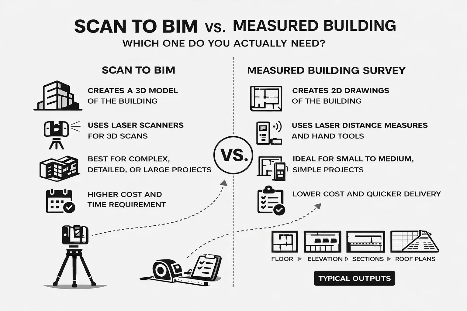
What a Measured Building Survey Actually Delivers
A measured building survey is the traditional backbone of existing conditions work. Despite newer technologies, it remains widely used across the UK for good reasons.
At its core, a measured building survey captures the geometry of a building and translates it into drawings that people can read and use easily.
Typical Outputs Include:
- 2D Floor Plans. Clear layouts showing room sizes, wall positions, door and window locations, and circulation. These are often the primary reference for planning submissions, space planning, and early design work.
- Elevations. External and sometimes internal elevations that document facade proportions, opening positions, and overall building height. Useful for planning, conservation, and visual checks, but limited in showing depth or construction buildup.
- Sections. Vertical cuts through the building that clarify floor-to-floor heights, structural levels, stair arrangements, and roof relationships. Sections help explain how spaces stack, but they rely on interpretation between cut lines.
- Roof Plans. Plans showing roof geometry, slopes, edges, and major features such as plant zones or rooflights. These are particularly relevant for extensions, drainage studies, and coordination with planning authorities.
- Sometimes Reflected Ceiling Plans. Provided when required, these illustrate ceiling grids, bulkheads, soffits, and visible services. They are typically schematic and not intended for detailed services coordination.
These drawings are usually delivered in AutoCAD or PDF format and are dimensionally controlled, meaning key distances and levels can be relied on for design. What they do not provide is behavioral information. They describe what exists in a static sense, not how elements relate spatially in three dimensions, how tolerances vary, or how different systems interact once design moves beyond the page.
How the Data Is Collected
Data for a measured building survey is gathered using a combination of established surveying tools and controlled measurement techniques. This often includes total stations for setting out and capturing key geometry, along with handheld laser distance devices for internal measurements and spot checks. Surveyors work from known control points, allowing other features to be positioned through measured distances and angles rather than continuous surface capture.
In some cases, laser scanning may also be used as part of the capture process, particularly in larger or more complex buildings. However, this does not automatically mean the project becomes scan to BIM. The defining factor is the output. Even when scanning is involved, the end deliverable for a measured building survey remains a set of 2D drawings, not a BIM model.
This is why the term measured building survey BIM is often used loosely. In many projects, there is no actual BIM environment or parametric model involved at all. The BIM reference usually indicates that the drawings are accurate, coordinated, and suitable for use by BIM teams later, not that a Revit model has been produced.
Strengths and Limitations of a Measured Building Survey
Where Measured Building Surveys Work Best
Measured building surveys do one job extremely well. They provide clear, reliable drawings without overwhelming the project with unnecessary information. For many projects, that simplicity is not a compromise but an advantage.
They work best when the building geometry is relatively straightforward, coordination demands are limited, and the scope of work is clearly defined from the outset. In these situations, 2D drawings are often exactly what the project needs. Layouts are easy to read, dimensions are controlled, and the information can be shared and reviewed without specialist tools or training.
This makes measured surveys a strong fit for planning submissions, lease plans, early feasibility studies, and straightforward refurbishments where major structural or services changes are not expected. The focus stays on clarity and speed rather than data richness.
Practical Advantages in Day-to-Day Delivery
From a delivery perspective, measured building surveys tend to be quicker and more economical at the front end. They usually require less time on site, involve simpler processing workflows, and are easier to brief and review. The resulting drawings can be issued in familiar formats such as AutoCAD or PDF, allowing design teams to start working immediately without needing to manage or interpret a BIM environment.
Because there is no requirement for parametric modeling or model maintenance, the process remains lightweight. For smaller or medium-sized buildings, this often results in faster turnaround and lower upfront costs, with little loss of value.
Where Measured Surveys Begin to Fall Short
The limitations of measured building surveys become more apparent as project complexity increases. When buildings include irregular layouts, sloping floors, historic elements, or layered services, 2D drawings start to rely heavily on interpretation. Critical relationships between elements may only be implied rather than clearly defined.
Measured surveys also offer no inherent three-dimensional coordination. Assumptions are often made between measured points, which can introduce risk when tolerances matter or when multiple disciplines are working in parallel. Validating clashes, clearances, and spatial conflicts becomes difficult without additional information.
At this stage, drawings can begin to conceal issues rather than expose them. That is often the point where teams start to reassess whether a measured building survey is still the right tool, or whether a scan to BIM approach would provide better support for the decisions that follow.
What Scan to BIM Really Means in Practice
Scan to BIM is often reduced to laser scanning, but that only describes the first step. In reality, scan to BIM is a structured workflow that turns captured spatial data into a usable digital model. The scan itself is just the starting point. The real value comes from what happens after the data is collected.
The process begins with a point cloud survey, where laser scanners capture millions of spatial points across the building. Each point represents a real-world coordinate, and together they form a detailed digital snapshot of existing conditions. This data reflects what is physically present on site, not what previous drawings suggest should be there.
From Point Cloud to BIM Model
Once the point cloud is registered, it is processed and cleaned to remove noise, align scan positions, and prepare the dataset for modeling. Geometry is then interpreted and translated into a BIM environment, most commonly Revit. Elements such as walls, floors, structure, and key features are modeled to an agreed level of detail based on how the information will be used downstream.
This stage is where expertise matters most. Decisions are made about what to model, how accurately, and to what level of detail. The goal is not to model everything, but to model what the project actually needs.
Why the Point Cloud Matters
Point cloud surveys are especially valuable when existing information cannot be trusted. This includes buildings with outdated or missing drawings, structures that have gone through multiple refurbishments, or projects where tolerances and spatial relationships directly affect design decisions.
Because the data is captured directly from the site, it provides a reliable foundation that reduces assumptions. Design teams can reference actual conditions rather than working around gaps or uncertainties in legacy information.
What Scan to BIM Outputs Look Like
The outputs of a scan to BIM project reflect a shift from static documentation to coordinated digital information. Instead of a set of 2D drawings, the deliverable is a model that can be interrogated, coordinated, and reused throughout the project lifecycle.
Typical scan to BIM outputs include:
- A Revit-based BIM model built from point cloud data
- Consistent, aligned geometry across levels and spaces
- Parametric elements that respond to changes and updates
- Discipline-specific models when architectural, structural, and services coordination is required
- Data-rich objects whose level of information is defined by the project scope
Because the information lives within a model rather than on separate drawings, geometry can be filtered, queried, and extracted as needed. This makes scan to BIM particularly effective for projects where coordination between architecture, structure, and building services plays a central role in design and delivery.
How Scan to BIM Differs from Measured Survey Outputs
This is where scan to BIM differs fundamentally from measured building survey BIM approaches. Rather than describing existing conditions in two dimensions, scan to BIM produces a working digital representation of the building. The emphasis shifts from documentation to decision support, making it far better suited to projects where coordination, accuracy, and long-term use of data matter.
2D Plans vs Revit Models: A Practical Comparison
This is often where decisions stall, because both options can technically work, but only one will support the project properly as it develops. The table below highlights the practical differences.
| Aspect | 2D Plans | Revit Models |
| Primary Use | Clear documentation of layout and dimensions | Coordinated digital representation of the building |
| Best Fit When | Layout clarity is the main requirement | Multiple disciplines rely on the same base information |
| Design Changes | Suited to minimal or infrequent changes | Handles frequent iterations and design development |
| التنسيق | Limited, largely manual | Built-in 3D coordination across elements |
| Services Integration | Typically schematic or omitted | Suitable for detailed services coordination |
| Tolerances and Accuracy | Adequate for simple geometry | Critical when tolerances affect construction |
| Project Stage | Early design, planning, or documentation | Design development through construction and beyond |
| Reuse of Information | Low, drawings are static | High, model can be reused across BIM stages |
Both approaches have a place. The right choice depends less on preference and more on how the information will be used once design work begins to move beyond the page.
Refurbishment vs New Build: Why Context Matters
For New Build Projects
On new build projects, measured building surveys are rarely central beyond providing site context and basic reference information. The geometry of the building is driven by design intent rather than existing conditions, so there is usually little need to capture detailed internal data.
Scan to BIM may still play a supporting role in specific situations. This is most common when new construction interfaces with existing buildings, when adjacent structures need to be referenced accurately, or when working on brownfield sites where legacy elements affect the design. In these cases, scanning helps clarify constraints, but it is not typically the backbone of the project.
For Refurbishment and Retrofit
Refurbishment and retrofit projects place existing conditions at the centre of decision-making. This is where scan to BIM becomes significantly more valuable. Unlike new builds, these projects depend on understanding what is already there, including deviations from original drawings and changes made over time.
Having accurate as-built geometry reduces assumptions and gives design teams visibility into conditions that would otherwise remain hidden. This leads to fewer surprises once work moves on site and supports more confident coordination between architecture, structure, and services. For buildings that have evolved through multiple phases, scan to BIM often provides a level of certainty that 2D drawings alone cannot achieve.
A Simple Decision Tree
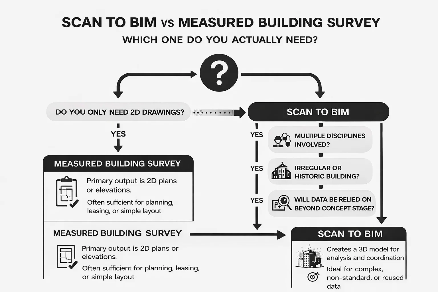
If the choice between a measured building survey and scan to BIM feels unclear, stepping back and asking a few practical questions often brings the answer into focus. The goal is not to pick the more advanced option, but the one that supports the decisions your team actually needs to make.
Ask yourself the following:
- Do you only need drawings for planning, leasing, or layout? If the primary output is a set of clear 2D plans or elevations, and there is no expectation of ongoing coordination, a measured building survey is often sufficient.
- Will multiple disciplines rely on the same base information? When architects, structural engineers, and services designers all depend on the same existing conditions data, a coordinated model becomes far more effective than separate drawings.
- Is the building complex, irregular, or historic? Buildings with non-standard geometry, layered construction, or long histories tend to reveal their challenges only when viewed in three dimensions. These are strong candidates for scan to BIM.
- Will this data be reused beyond concept stage? If the information will feed into design development, coordination, or construction planning, investing in a model early often pays off. If the data will be used once and archived, drawings may be the better fit.
Taken together, the answers usually point clearly toward one approach. The more your project depends on accuracy, coordination, and reuse, the stronger the case for scan to BIM becomes.
When Hybrid Approaches Make Sense
Not every project fits neatly into a single category, and in many cases the most effective solution sits somewhere between a measured building survey and a full scan to BIM workflow. Hybrid approaches are becoming more common, particularly on projects where certain areas demand high accuracy while others remain relatively simple.
A point cloud survey can be used to capture critical zones where tolerances, interfaces, or existing constraints matter most. This might include plant rooms, structural tie-ins, service-heavy areas, or sections of a building scheduled for major intervention. Elsewhere, measured drawings may be perfectly adequate, providing clear layouts and dimensions without the cost or complexity of full modeling.
Partial BIM modeling is often introduced selectively, focused on coordination zones where multiple disciplines overlap or where design risk is highest. By limiting the scope of modeling to what is actually needed, teams can protect key design decisions while keeping budgets and workflows under control.
This blended approach avoids the extremes of underproduction and overproduction. It delivers precision where it counts, simplicity where it does not, and often results in a more efficient use of both survey data and design resources.
الأفكار النهائية
Scan to BIM and measured building surveys are not competitors. They are responses to different problems.
If you need clarity and speed, measured surveys work. If you need accuracy, coordination, and long-term value, scan to BIM is often the better choice.
The right decision starts with understanding what you actually need.
الأسئلة الشائعة
Is Scan to BIM the same as a point cloud survey?
No. A point cloud survey is only one part of the scan to BIM process. The point cloud is the raw data captured on site using laser scanners. Scan to BIM goes further by interpreting that data and converting it into a structured BIM model, usually in Revit. You can have a point cloud without a BIM model, but you cannot have scan to BIM without a point cloud.
Does a measured building survey mean there is a BIM model?
Not necessarily. The term measured building survey BIM is often used loosely. In most cases, a measured building survey delivers 2D drawings such as plans, sections, and elevations, not a BIM model. The drawings may be accurate enough to support BIM work later, but that does not mean a Revit model has been created.
Which option is better for refurbishment projects?
For refurbishment and retrofit projects, scan to BIM is often the better option, especially when existing drawings are unreliable or incomplete. Having accurate as-built geometry reduces assumptions and helps avoid surprises during design and construction. Measured surveys can still work for simple refurbishments, but their limitations become more apparent as complexity increases.
When is a measured building survey enough?
A measured building survey is usually sufficient when the project requires clear layouts and dimensions but does not involve complex coordination. Planning submissions, lease plans, feasibility studies, and straightforward internal changes often fall into this category. If the data will not be reused beyond early stages, drawings are often the most efficient solution.
Is Scan to BIM always more accurate than a measured survey?
Not always in every context. Measured surveys can be very accurate for specific points and dimensions. The advantage of scan to BIM lies in comprehensive accuracy across the entire building, rather than precision at isolated locations. It captures relationships, tolerances, and deviations that are difficult to represent fully in 2D.

هل لديك مشروع BIM؟ تحدث إلينا.
اتصل بنادراسات الحالة لدينا
لقد تعاملنا مع أكثر من 200 مشروع من مشاريع نمذجة معلومات المباني ونمذجة معلومات المباني للقطاعات التجارية والصناعية والسكنية.
يشمل عملنا ما يلي:
أتمتة تصميم القوالب
Our client from
California, USA
أتمتة تصميم السقف المعلق
Our client from
New York, USA
أتمتة تصميم إطارات الحائط
Our client from
California, USA