هل لديك أي أسئلة؟ اتصل بنا!
انضم إلى فريقنا!
اطلب عرض أسعار أو استشارة مجانية

How Accurate Is Laser Scanning for Buildings? Tolerances, Control, and When It’s Good Enough for Construction
Laser scanning has earned a reputation for being “extremely accurate,” but that phrase rarely tells the full story. On a real building, accuracy is shaped by more than the scanner itself. Control networks, registration quality, site conditions, and how the data is used all matter just as much.
In practice, the question is not whether laser scanning is precise in theory, but whether it is precise enough for the task at hand. Designing a renovation, coordinating structure and MEP, and verifying what was actually built all demand different tolerances. A model that works perfectly for early design may fall short when used for fabrication checks or compliance verification.
This article breaks down what laser scanning accuracy really means on buildings. We’ll look at expected accuracy bands, how control and registration affect results, and where the line usually sits between “technically accurate” and “good enough for construction decisions.”
What Accuracy Means in Building Laser Scanning
Accuracy in laser scanning is often confused with precision, and the two are not the same.
Precision refers to how consistent the measurements are. Accuracy refers to how close those measurements are to reality. A scan can be very precise and still be wrong if it is not properly controlled or referenced.
For buildings, accuracy usually means how closely the point cloud or derived model represents the true position of walls, floors, structure, and services within an accepted tolerance. That tolerance depends on the task. Measuring a corridor width for space planning is not the same as checking whether steel embeds are in the correct location.
Another important point is that accuracy is three-dimensional. Errors can appear horizontally, vertically, or as rotational drift. Many problems in construction scans come not from obvious mistakes, but from small misalignments that only show up when models are compared or overlaid later.
Typical Accuracy Ranges in Real Projects
Manufacturers often quote impressive numbers, sometimes down to one millimeter under ideal conditions. On site, results are different, and that is normal.
For static terrestrial laser scanning used on buildings, common real-world accuracy bands look roughly like this:
- At short ranges, up to 10 meters, point accuracy of 2 to 3 mm is achievable with high-end equipment and good practice.
- At medium ranges, around 20 to 30 meters, accuracy often sits in the 3 to 6 mm range.
- At longer ranges, or in complex interiors with occlusions, errors can grow beyond that if control and registration are weak.
These numbers describe the scan data itself, not the final drawings or models. Every step after scanning introduces interpretation and simplification, which can add its own tolerances.
Whether your data comes from static or mobile scanning systems, Powerkh aligns the modeling strategy to the source’s limitations. For mobile-scanned data, we focus on high-level spatial planning (LOD 200), while for high-precision terrestrial scans, we deliver fabrication-ready coordination models.
Accuracy With Purpose: How We Maintain Design Continuity on Site at Powerkh

في باورخ, we transform raw point cloud data into high-precision BIM environments that drive decision-making. As an engineering-led digital construction consultancy, we specialize in Scan to BIM processing across all project stages, from early RIBA design to LOD 500 as-built verification. Our role is to ensure that the modeling tolerance matches your engineering requirements, whether you’re coordinating complex MEP or detailing structural steel.
We work with laser scanning and existing conditions data to establish a reliable base for design and coordination, typically during early RIBA stages. From there, we carry that information forward through coordination, critical zone resolution, and technical design review. When projects reach site, we shift focus from modeling to verification. We compare design intent with reality, explain which deviations matter, and help teams act on real risk rather than noise. In that context, “good enough” accuracy is defined by purpose. Design support, coordination, and construction verification each demand different tolerances, and we plan our workflows accordingly.
This continuity-led approach is what allows accuracy to hold up under pressure. By combining engineering judgment, BIM, and reality-based verification, we help teams avoid the common gap between what was designed and what gets delivered. The goal is simple and practical: make sure what’s designed is what gets built, with fewer surprises along the way.
Why Control Networks Matter More Than the Scanner
One of the biggest misconceptions about laser scanning is the idea that better hardware automatically guarantees better accuracy. In real projects, control networks usually have a much bigger impact than the scanner itself.
A control network is a set of known reference points used to anchor scan data to a stable coordinate system. These points are typically established using total stations or GNSS, depending on the site and required precision. Once in place, they provide fixed references that guide how individual scan stations are positioned and aligned.
Without control, scans rely entirely on relative positioning between stations. That approach can work on small, simple sites, but as buildings become larger or more complex, small errors start to accumulate. Floors may appear slightly tilted, long corridors can drift over distance, and separate rooms that should align may end up subtly mispositioned when brought together.
When a proper control network is used, scan stations are constrained to known positions, registration errors are reduced, and the data can be reliably compared to design models or future scans. This consistency is especially important on phased projects or sites that are scanned multiple times over the course of construction.
Registration: Where Most Errors Are Introduced
Registration is the process of aligning multiple scans into a single coordinate system. This is where many accuracy issues appear, even when the raw scan data is good.
Registration can be done in several ways:
- Target-based registration using spheres or checkerboards.
- Cloud-to-cloud registration based on overlapping geometry.
- Control-based registration using surveyed points.
Each method has strengths and weaknesses. Cloud-to-cloud registration is fast and often sufficient for visual documentation, but it depends heavily on overlap and geometry. Long, featureless spaces like corridors or open halls are especially vulnerable to drift.
Target-based and control-based registration are slower, but far more robust. By introducing fixed references, they prevent small alignment errors from compounding as datasets grow. This becomes critical on multi-floor buildings or phased projects, where even minor drift can create significant coordination issues later.
Poor registration rarely looks dramatic at first glance. Models still appear clean and well-formed. Problems usually surface later, when measurements are checked, trades clash, or models from different sources fail to line up. By that point, rework is expensive and confidence in the data has already been lost.
While control-based registration happens on site, Powerkh adds an additional layer of protection before any modeling begins. We carry out a rigorous point cloud audit, reviewing registration reports and checking for drift, misalignments, or inconsistencies across floors and zones. By identifying these issues in the raw data early, we prevent registration errors from quietly propagating into the final Revit model, where they are far harder to correct and far more costly to ignore.
Environmental and Site Factors That Affect Accuracy
Even with good equipment and control, site conditions influence results.
Distance matters. The farther the scanner is from a surface, the more noise and uncertainty enter the measurement. That is why scan planning is critical. Fewer scan positions taken from far away often produce worse results than more scans taken closer.
Surface properties also play a role. Highly reflective, transparent, or very dark surfaces can distort returns. Glass, polished metal, and wet surfaces are common troublemakers in buildings.
Movement is another factor. Scanning active sites introduces risk. People, machinery, and temporary elements can contaminate data. Experienced teams know how to filter this out, but it adds processing complexity.
Lighting generally does not affect laser distance measurement directly, but it can affect imagery used for colorization or photogrammetry-based workflows.
From Point Cloud to Deliverables: Where Interpretation Begins
Point clouds are dense, detailed, and honest. Models and drawings are not. They are interpretations.
When point clouds are converted into 2D drawings or BIM models, decisions are made about:
- What to include or ignore
- How to represent irregular geometry
- What level of detail is appropriate
Each of these decisions introduces tolerance. A wall that is slightly bowed may be modeled as straight. A floor that slopes subtly may be flattened to a datum. These are not mistakes, but conscious choices aligned with the intended use.
Problems arise when the modeling tolerance is not clearly defined or communicated. A model built for design coordination should not be reused blindly for fabrication or layout.
Expected Accuracy Bands by Use Case
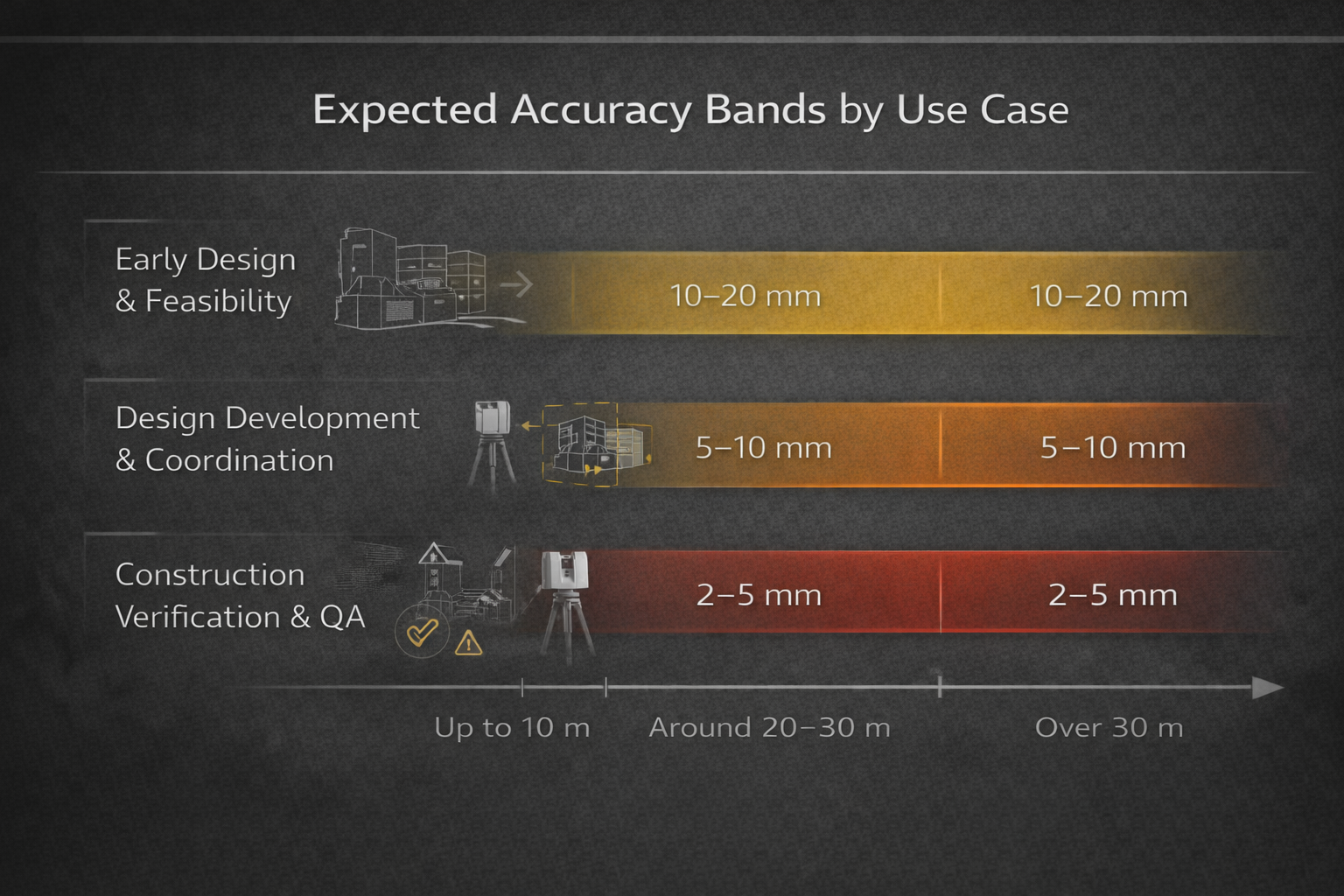
To make sense of laser scanning accuracy, it helps to think in bands tied to purpose rather than absolute numbers.
Early Design and Feasibility
For concept design, space planning, and high-level studies, accuracy within 10 to 20 mm is often sufficient. At this stage, understanding relationships and constraints matters more than exact dimensions.
Laser scanning excels here because it provides context and completeness, even if the tolerance is relatively loose.
Design Development and Coordination
As projects move into coordination, expectations tighten. Accuracy in the 5 to 10 mm range is commonly expected, assuming good control and registration.
This level supports clash detection, alignment checks, and integration with design models. It is also where Scan to BIM workflows deliver the most value.
Construction Verification and QA
For verification, layout checks, or compliance-related work, tolerances become much stricter. In many cases, teams expect accuracy within 2 to 5 mm, sometimes less.
At this level, control networks, disciplined registration, and careful modeling are essential. Not all scan data is suitable for this purpose, and that is an important reality to acknowledge.
What “Good Enough” Really Means on Site
“Good enough” is not a technical term, but it is how decisions are made on real projects.
A scan is good enough if it allows a team to make a decision with confidence, without introducing unacceptable risk. That definition changes depending on who is using the data.
Architects may accept looser tolerances than steel fabricators. Facilities teams may prioritize completeness over millimeter accuracy. Inspectors may care more about traceability than density.
Problems occur when expectations are mismatched. A model delivered without clarity about its accuracy and intended use invites misuse.
Good practice means stating:
- What accuracy band the data falls into
- How control and registration were handled
- What the model is suitable for, and what it is not
This transparency protects both the provider and the client.
Digital Twins and the Myth of Absolute Accuracy
The term digital twin is often used loosely. In reality, a building digital twin is only as reliable as its underlying data and assumptions.
Laser scanning provides a strong foundation, but a digital twin is still a model. It represents reality within defined tolerances and at a specific moment in time.
Expecting a digital twin to replace surveying, inspection, or judgment is unrealistic. Used correctly, it becomes a powerful decision-support tool. Used blindly, it becomes a source of false confidence.
Choosing the Right Scanning Approach
Not every project needs maximum accuracy, and not every budget is built to support it. The right scanning approach is usually a balance between several factors, including the tolerance required for the task, the size and complexity of the site, how accessible the space is, the project schedule, and how the data will be used later on.
Static terrestrial laser scanning combined with a proper control network remains the gold standard for building accuracy, especially when the data will be used for coordination, verification, or detailed modeling. That level of rigor, however, is not always necessary. On large sites or early-stage projects, mobile systems and hybrid workflows can be more practical, particularly when speed and coverage matter more than tight tolerances.
What matters most is making an intentional choice. Selecting scanning technology based on project needs, rather than defaulting to whatever equipment is available, is what keeps accuracy aligned with real construction requirements.
Common Mistakes That Undermine Accuracy
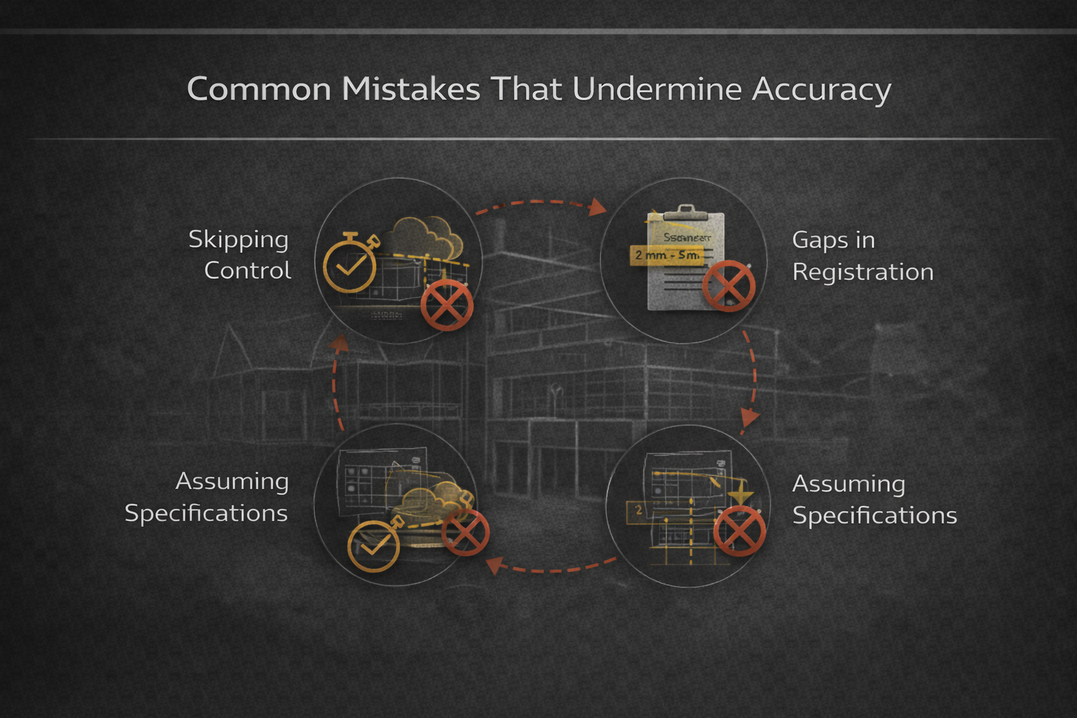
Across projects of all sizes, the same accuracy problems tend to surface again and again. They are rarely the result of poor equipment. More often, they come from assumptions made early in the process.
- Skipping control to save time. Omitting a control network may speed up field work, but it almost always increases risk later. Without control, small registration errors can compound across a building, especially on multi-floor or phased projects.
- Over-relying on cloud-to-cloud registration. Cloud-to-cloud alignment works well in compact spaces with strong geometry, but it becomes unreliable in long corridors, open areas, or repetitive layouts. Without fixed references, drift can go unnoticed until models are already in use.
- Assuming manufacturer specifications apply on site. Accuracy figures published by scanner manufacturers are typically achieved under ideal conditions. Real buildings introduce distance, surface, and environmental variables that reduce those numbers in practice.
- Using design models for verification without checking tolerances. Design models often simplify geometry for clarity and coordination. Treating them as verification-grade references without confirming their modeling tolerance can lead to false conclusions about what is actually built.
- Reusing scan data outside its original scope. Scan data collected for early design or visualization is not automatically suitable for construction checks or compliance work. Accuracy expectations need to be reassessed whenever data is repurposed.
None of these mistakes are unusual or hard to avoid. They tend to happen when accuracy is assumed rather than defined, controlled, and checked throughout the scanning and modeling process.
Laser Scanning as a Controlled Process
The most important takeaway is that laser scanning accuracy is not a feature. It is a process.
It starts with defining what accuracy is required. It continues through scan planning, control setup, registration strategy, and modeling decisions. It ends with clear communication about what the data can and cannot support.
When handled this way, laser scanning becomes one of the most reliable sources of existing conditions data available to construction teams. Not because it is perfect, but because its limits are understood and managed.
الأفكار النهائية
Laser scanning is neither magic nor guesswork. It sits somewhere in between, governed by physics, process, and professional judgment.
Understanding tolerances, control networks, and registration is what turns scan data into something construction teams can trust. Just as important is knowing when accuracy is sufficient, and when it is not.
In the end, the value of laser scanning is not measured in millimeters alone. It is measured in fewer surprises, better decisions, and confidence that the building you are designing or verifying matches the one that actually exists.
الأسئلة الشائعة
How accurate is laser scanning for buildings in real conditions?
In real projects, static terrestrial laser scanning typically achieves accuracy in the range of 2 to 6 mm, depending on distance, equipment, site conditions, and how the scans are controlled and registered. Lab specifications are often tighter, but on-site accuracy is shaped by workflow as much as by hardware.
Is laser scanning accurate enough for construction work?
Yes, when it is planned and controlled correctly. Laser scanning is widely used for construction coordination, verification, and quality checks. The key is matching the expected tolerance of the scan to the task. What works for design coordination may not be sufficient for fabrication or compliance verification.
What affects laser scanning accuracy the most?
Control networks and registration have the biggest impact. Even the best scanner cannot compensate for weak control, poor scan geometry, or careless registration. Distance to surfaces, site conditions, and post-processing decisions also play important roles.
What is a control network and why does it matter?
A control network is a set of surveyed reference points that anchors scan data to a known coordinate system. It prevents cumulative errors, reduces drift, and allows scan data to be reliably compared to design models or future scans. For construction verification, control is essential.
How does registration influence accuracy?
Registration aligns multiple scan stations into a single dataset. Errors introduced during registration can shift or rotate data even if individual scans are precise. Target-based or control-based registration generally produces more reliable results than cloud-to-cloud methods alone.

هل لديك مشروع BIM؟ تحدث إلينا.
اتصل بنادراسات الحالة لدينا
لقد تعاملنا مع أكثر من 200 مشروع من مشاريع نمذجة معلومات المباني ونمذجة معلومات المباني للقطاعات التجارية والصناعية والسكنية.
يشمل عملنا ما يلي:
أتمتة تصميم القوالب
Our client from
California, USA
أتمتة تصميم السقف المعلق
Our client from
New York, USA
أتمتة تصميم إطارات الحائط
Our client from
California, USA